place

Red Hill water crisis
2021 disasters in the United States2021 in Hawaii2022 disasters in the United States2022 in HawaiiPollution events in 2021
Pollution events in 2022Red Hill Underground Fuel Storage FacilityUse American English from July 2022Use mdy dates from June 2022Water supply and sanitation in the United States
Redhillops
Redhillops

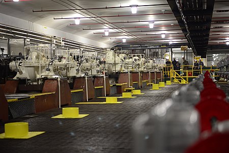
The Red Hill water crisis is a public health crisis and environmental disaster caused by fuel leaking from the Red Hill Underground Fuel Storage Facility into the freshwater aquifer underneath the island of Oʻahu. Residents in military housing in and around Joint Base Pearl Harbor–Hickam began reporting chemical contamination in their tap water near the end of November 2021, and the Hawaiʻi Department of Health advised residents to stop using their tap water on November 29, 2021. All residents of the area (not just military housing) were unable to use their tap water until the following March, after their water system was flushed of contaminants.The fuel spill from the Red Hill facility also forced the shutdown of several water sources operated by the Honolulu Board of Water Supply that provided drinking water for urban Honolulu. Due to uncertainty about the spread of fuel contamination underground, these water sources will remain shut down indefinitely, which has caused a shortage of water for Honolulu residents. Voluntary water usage reductions were announced on March 10, 2022, and compliance has avoided the imposition of mandatory water restrictions as of May 2022.

Excerpt from the Wikipedia article Red Hill water crisis (License: CC BY-SA 3.0, Authors, Images).

Red Hill water crisis
Halawa Valley Street, Honolulu Moanalua Valley

Geographical coordinates (GPS) Address Nearby Places
placeShow on map

Wikipedia: Red Hill water crisisContinue reading on Wikipedia

Geographical coordinates (GPS)

Latitude Longitude
N 21.373888888889 ° E -157.89388888889 °
placeShow on map

Address

Halawa Correctional Facility

Halawa Valley Street
96859 Honolulu, Moanalua Valley
Hawaii, United States
mapOpen on Google Maps

Redhillops
Redhillops
Share experience

Nearby Places

Keaīwa Heiau State Recreation Area

Keaīwa Heiau State Recreation Area is the ruins of a temple (Heiau in the Hawaiian language) at the summit of a hill and neighborhood called ʻAiea Heights on Oʻahu, Hawaiʻi. The recreation area includes camping facilities and a 4.8-mile (7.7 km) trail. It also offers clear views of Pearl Harbor. The high point of Puu Uau is about halfway down the trail, where native ohia lehua and koa trees may be viewed. The remains of a military plane that crashed in 1944 can also be seen along the trail. The hike is not particularly difficult, however it does include one quite steep switchback stretch and can be extremely muddy if it has just rained. Allow for around 2.5 hours of easy strolling. A possible translation of Keaʻiwa would be mysterious, incomprehensible. It is believed that this name was given in reference to the healing powers of the plants that no one could really explain. In addition, Keaiwa Heiau may have also been known as a "Heiau Hoʻola," or the healing or life-giving heiau according to native Hawaiian scholar Mary Kawena Pukui.Foresters replanted most of this area in the late 1920s. The lemon eucalyptus trees give forth a mild citrus scent in the air. The trail's lower end is marked by stands of Norfolk Island pine trees. Pu'u Uau, the trail's high point around halfway along the length, is surrounded by native koa and ohi'a trees. There is also wreckage of a B-24 aircraft that went down in 1944. The name "Keʻaiwa" means "strange" or "incomprehensible" in Hawaiian. Perhaps the name refers to the idea that the powers of the kahuna and the plants employed in healing are unfathomable.Erected sometime in the 16th century by Kakuhihewa, the 15th Aliʻi ʻAimoku, or ruling chief, of Oahu, the 100 feet (24 m) by 160 feet (49 m) stone temple had walls averaging 4 ft in height and 5 ft in width. The walls consisted of numerous evenly faced one foot stones that are filled with rubble. Abundant medicinal herbs in the area were used by kahuna as a type of ancient herbal clinic. The kahuna would also train haumana (students) interested in the art of laʻau lapaʻau (healing medicine). The kahuna would also train students in the practice of praying, fasting, and medicinal healing using the neighboring plants. The reputed healing powers of the surrounding plants still draws visitors who leave temple offerings, hoping to experience medicinal benefits.Most of the trees in the area were replanted during the early 20th century. Although native species can be found at the highpoint of the trail. The remnants of a military airplane that crashed onto the area in 1993 can also be seen from the trail.The site provides a map for the 4.5 miles (7.2 km) Aiea Loop Trail. Several varieties of trees and other vegetation are enjoyed by visitors who make the trek.