Givat HaMoreh
Book of DeuteronomyBook of GenesisBook of JudgesHebrew Bible mountainsLech-Lecha ... and 1 more
Torah places

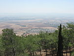
Givat HaMoreh (Hebrew: גבעת המוֹרֶה, Arabic: جبل الدحي, romanized: Jebel ed-Dahi) is a hill in northern Israel on the northeast side of the Jezreel Valley. The highest peak reaches an altitude of 515 metres (1,690 ft), while the bottom of the Jezreel Valley is situated at an altitude of 50–100 metres (160–330 ft). North of it are the plains of the Lower Galilee and Mount Tabor. To the east, Giv'at HaMoreh connects to the Issachar Plateau. To the southeast it descends into the Harod Valley, where the 'Ain Jalut flows eastwards into the Jordan Valley.
Excerpt from the Wikipedia article Givat HaMoreh (License: CC BY-SA 3.0, Authors, Images).Givat HaMoreh
Afula
Geographical coordinates (GPS) Address Website Nearby Places Show on map
Geographical coordinates (GPS)
| Latitude | Longitude |
|---|---|
| N 32.615833333333 ° | E 35.363611111111 ° |
Address
עפולה
1839010 Afula
North District, Israel
Open on Google Maps


