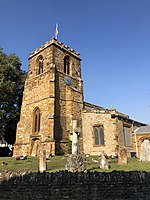
East Hunsbury

East Hunsbury is a large residential area in the south of Northampton, England, situated around 3 miles (5 km) from the town centre and 1 mile (2 km) from junction 15 of the M1 motorway. For administrative purposes it is part of the unitary authority of West Northamptonshire. It is part of the Hunsbury conglomeration, which also includes West Hunsbury on the west side of Towcester Road. Shelfleys is the original name for the area of Northampton currently referred to as West Hunsbury. The name of West Hunsbury still appears on maps for the district as Shelfleys. Merefield is the corresponding name for East Hunsbury, together with the name "Blacky More" for the eastern part of East Hunsbury. All three names are still on local direction signs in Northampton, although older references are no longer in use by the local people living there. The areas developed in the 1980s and 1990s as part of the expansion of Northampton. The Northampton loop of the West Coast Main Line railway running between Northampton and London Euston runs under East and West Hunsbury via the Hunsbury Hill Tunnel emerging near Hill Farm Rise which follows the original course of Towcester Road prior to the 1980s. Ventilation shafts are visible in the housing estate in Yeoman Meadow. East Hunsbury was awarded ‘Best Large Village’ in 2019 by NorthantsAcre.[1]
Excerpt from the Wikipedia article East Hunsbury (License: CC BY-SA 3.0, Authors, Images).East Hunsbury
Granary Road,
Geographical coordinates (GPS) Address Nearby Places Show on map
Geographical coordinates (GPS)
| Latitude | Longitude |
|---|---|
| N 52.207333 ° | E -0.9 ° |
Address
Granary Road
Granary Road
NN4 0XS , East Hunsbury
England, United Kingdom
Open on Google Maps


