Place d'Armes (Quebec City)
1648 establishments in the British EmpireParks in Quebec CityQuebec City stubsUrban public parksUse mdy dates from November 2021

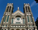
Place d'Armes is an urban park in Quebec City, Quebec, Canada. It is bounded by Rue Saint-Anne to the north, Fort Street to the east, Rue Saint-Louis to the south and Rue du Trésor to the west. The park's name means a place of arms, which is the gathering place of a small troop and a central space hosting the important ceremonies of military life. The park has a monument, part of a fountain (erected in 1915), in its centre. The park was created between 1640 and 1648 by Governor Charles Jacques Huault de Montmagny. It became a public park in 1865. The Château Frontenac overlooks the square from the south, and the Cathedral of the Holy Trinity from the west.
Excerpt from the Wikipedia article Place d'Armes (Quebec City) (License: CC BY-SA 3.0, Authors, Images).Place d'Armes (Quebec City)
Rue Sainte-Anne, Quebec
Geographical coordinates (GPS) Address Nearby Places Show on map
 Continue reading on Wikipedia
 Geographical coordinates (GPS)
| Latitude | Longitude |
|---|---|
| N 46.8126026 ° | E -71.20580028 ° |
Address
Rue Sainte-Anne 16
G1R 4A2 Quebec (La Cité-Limoilou)
Quebec, Canada
Open on Google Maps