Kyttälä
KyttäläWestern Finland Province geography stubs

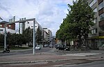
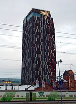
Kyttälä is a district in Tampere, Finland. It was born in the late 1870s as a working-class neighborhood to the eastern outskirts of the town. As Tampere soon expanded, Kyttälä is now a part of the city center between the Tammerkoski river and the railway. Population of Kyttälä is 3,348 (31 December 2014). Aleksanterinkatu is one of Kyttälä's main streets. The direct connection to the Liisankallio district and from there to Teiskontie and Sammonkatu streets runs along Itsenäisyydenkatu and connection to the Jussinkylä district runs along Tuomiokirkonkatu.
Excerpt from the Wikipedia article Kyttälä (License: CC BY-SA 3.0, Authors, Images).Kyttälä
Rautatienkatu, Tampere Kyttälä (Keskustan suuralue)
Geographical coordinates (GPS) Address Nearby Places Show on map
 Continue reading on Wikipedia
 Geographical coordinates (GPS)
| Latitude | Longitude |
|---|---|
| N 61.498528 ° | E 23.771708 ° |
Address
Rautatienkatu
Rautatienkatu
33100 Tampere, Kyttälä (Keskustan suuralue)
Finland
Open on Google Maps