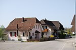
Aarwangen District
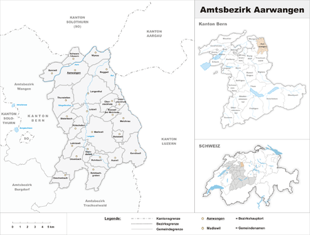
Aarwangen District is a constitutional district in the northeast corner of the canton of Bern in Switzerland, with its seat at Aarwangen. From 1 January 2010, the district lost its administrative power. Since 2010, it remains a fully recognised district under the law and the Constitution (Art.3 al.2) of the Canton of Berne. Its municipalities became part of the administrative region Emmental-Oberaargau. It is surrounded by the canton of Solothurn on the north, the canton of Aargau on the northeast, the canton of Lucerne on the east, the district of Trachselwald on the south, the district of Burgdorf on the southwest, and the district of Wangen on the west. The district includes the following 25 municipalities and has an area of 154 km2 (59 sq mi): CH-4912 Aarwangen CH-4944 Auswil CH-4913 Bannwil CH-3368 Bleienbach CH-4917 Busswil bei Melchnau CH-4955 Gondiswil CH-4932 Gutenberg CH-4936 Kleindietwil CH-4900 Langenthal CH-4935 Leimiswil CH-4932 Lotzwil CH-4934 Madiswil CH-4917 Melchnau CH-4924 Obersteckholz CH-4943 Oeschenbach CH-4919 Reisiswil CH-4914 Roggwil CH-4938 Rohrbach CH-4938 Rohrbachgraben CH-4933 Rütschelen CH-4911 Schwarzhäusern CH-4922 Thunstetten CH-4916 Untersteckholz CH-4937 Ursenbach CH-4923 Wynau
Excerpt from the Wikipedia article Aarwangen District (License: CC BY-SA 3.0, Authors, Images).Aarwangen District
Sonnhaldestrasse,
Geographical coordinates (GPS) Address Nearby Places Show on map
Geographical coordinates (GPS)
| Latitude | Longitude |
|---|---|
| N 47.2333 ° | E 7.76667 ° |
Address
Sonnhaldestrasse 32
4912
Bern, Switzerland
Open on Google Maps
