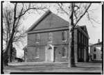
Marlboro (CDP), New Jersey
Census-designated places in Cumberland County, New JerseyCensus-designated places in New JerseyNew Jersey geography stubsStow Creek Township, New JerseyUse American English from June 2023 ... and 1 more
Use mdy dates from June 2023
Marlboro is a census-designated place (CDP) located in Stow Creek Township on the northwestern edge of Cumberland County, in the U.S. state of New Jersey. It is bordered to the northwest, across Sarah Run, by Quinton Township in Salem County. The CDP contains the unincorporated communities of Marlboro and Campbells Corner. New Jersey Route 49 passes through the CDP, leading southeast 6 miles (10 km) to Bridgeton, the Cumberland county seat, and northwest 10 miles (16 km) to Salem. Marlboro was first listed as a CDP prior to the 2020 census.
Excerpt from the Wikipedia article Marlboro (CDP), New Jersey (License: CC BY-SA 3.0, Authors).Marlboro (CDP), New Jersey
Quinton-Marlboro Road, Stow Creek Township
Geographical coordinates (GPS) Address Nearby Places Show on map
Geographical coordinates (GPS)
| Latitude | Longitude |
|---|---|
| N 39.485555555556 ° | E -75.319722222222 ° |
Address
Quinton-Marlboro Road 1329
08302 Stow Creek Township
New Jersey, United States
Open on Google Maps


