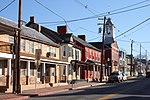
Zittlestown, Maryland
Unincorporated communities in MarylandUnincorporated communities in Washington County, MarylandUse mdy dates from July 2023Washington County, Maryland geography stubs
Zittlestown is an unincorporated community 2.2 miles (3.5 km) southeast of Boonsboro in Washington County, Maryland. It is situated on the western slope of South Mountain below Turner's Gap, along the historic National Pike, now designated U.S. Route 40 Alternate. Zittlestown is named after Michael Zittle, Sr. (1769-1850), who in 1811 purchased tracts of land there, and subdivided them.In the American Civil War, the Battle of South Mountain on 14 September 1862 was fought around Zittlestown.
Excerpt from the Wikipedia article Zittlestown, Maryland (License: CC BY-SA 3.0, Authors).Zittlestown, Maryland
Moser Road,
Geographical coordinates (GPS) Address Nearby Places Show on map
Geographical coordinates (GPS)
| Latitude | Longitude |
|---|---|
| N 39.485277777778 ° | E -77.623888888889 ° |
Address
Moser Road 6199
21713
Maryland, United States
Open on Google Maps


