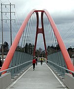
Lents, Portland, Oregon

The Lents neighborhood in the Southeast section of Portland, Oregon is bordered by SE Powell Blvd. on the north, the Clackamas County line or City of Portland line on the south (whichever is farther south), SE 82nd Ave. to the west, and roughly SE 112th on the east. The NE corner overlaps with the Powellhurst-Gilbert neighborhood. In addition to Powellhurst-Gilbert on the north and east, Lents also borders Foster-Powell, Mt. Scott-Arleta, and Brentwood-Darlington on the west and Pleasant Valley on the east. The neighborhood is one of the larger in the city at 3.75 square miles (9.7 km2) and one of its oldest. Since the late 20th century, it has become more diverse, the home of many Asian, Russian/Eastern European, and Latino immigrants.It is nicknamed "felony flats" owing to having the highest proportion of parolees anywhere in the Northwest. It was said in 2003 that the police referred to Lents as "felony flats": 57 : 10 Lents is six miles (10 km) southeast of downtown Portland and lies within the 97266 ZIP code.
Excerpt from the Wikipedia article Lents, Portland, Oregon (License: CC BY-SA 3.0, Authors, Images).Lents, Portland, Oregon
Southeast 99th Avenue, Portland Lents
Geographical coordinates (GPS) Address Nearby Places Show on map
Geographical coordinates (GPS)
| Latitude | Longitude |
|---|---|
| N 45.4754 ° | E -122.56207 ° |
Address
Southeast 99th Avenue 6517
97266 Portland, Lents
Oregon, United States
Open on Google Maps


