place

St Bartholomew's Chapel, Corton

Church of England church buildings in DorsetChurches in DorsetGrade II* listed churches in Dorset
Corton Chapel of St Bartholomew (geograph 1814729)

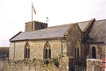
St Bartholomew's Chapel is a Church of England chapel in Corton, near Weymouth, Dorset, England. The chapel has early 13th century origins, with later rebuilds and a restoration of 1897. It is a Grade II* listed building.

Excerpt from the Wikipedia article St Bartholomew's Chapel, Corton (License: CC BY-SA 3.0, Authors, Images).

St Bartholomew's Chapel, Corton
Winter's Lane,

Geographical coordinates (GPS) Address Website External links Nearby Places
placeShow on map

Wikipedia: St Bartholomew's Chapel, CortonContinue reading on Wikipedia

Geographical coordinates (GPS)

Latitude Longitude
N 50.6678 ° E -2.5165 °
placeShow on map

Address

St Bartholomew

Winter's Lane
DT3 4ER , Portesham
England, United Kingdom
mapOpen on Google Maps

Website
achurchnearyou.com

linkVisit website

linkWikiData (Q17541322)
linkOpenStreetMap (248338335)

Corton Chapel of St Bartholomew (geograph 1814729)
Share experience

Nearby Places

Upwey, Dorset
Upwey, Dorset

Upwey is a suburb of Weymouth in south Dorset, England. The suburb is situated on the B3159 road in the Wey valley. The area was formerly a village until it was absorbed into the Weymouth built-up area. It is located four miles north of the town centre in the outer suburbs. During the Census 2001 the combined population of Upwey and neighbouring Broadwey was 4,349. The village has a 13th-century parish church, dedicated to Saint Laurence, and a manor house, Upwey Manor, which was owned by the Gould family. A disc barrow is located above the village on the Ridgeway at map reference SY 663866. The former United Reformed Church was built in 1880–81 and closed in 1992.The River Wey rises at the foot of the chalk ridge of the South Dorset Downs, which rise above Upwey to the north, and flows through the village. The source is known as the Upwey wishing well and was a tourist attraction as far back as the Victorian era. There is now a tea room at the site, complete with mature water gardens. In the 18th century a water mill was built on the river, rebuilt in 1802; it featured in Thomas Hardy's The Trumpet Major; he also wrote a poem "At the Railway Station, Upway", which most likely relates to Upwey station. Another famous name associated with Upwey is that of Lucille Ball the American actress, comedian who was proud of her family and heritage. Her genealogy can be traced back to the earliest settlers in the colonies. One direct ancestor, William Sprague (1609–1675), left England on the ship Lyon's Whelp for Plymouth/Salem, Massachusetts. They were from Upwey, Dorset, England. Along with his two brothers, William helped to found the city of Charlestown, Massachusetts. Other Sprague relatives became soldiers in the US Revolutionary War and two of them became governors of the state of Rhode Island. Upwey features in Edward Chaney's Genius Friend: G.B. Edwards and The Book of Ebenezer le Page as the place in which Chaney got to know Gerald Edwards and encouraged him to complete his novel. Edwards died in the since-demolished 654 Dorchester Road, Upwey, on 29 December 1976.Upwey lends its name to Upwey, Victoria, in Melbourne, near Belgrave, Victoria.

Hardy Monument
Hardy Monument

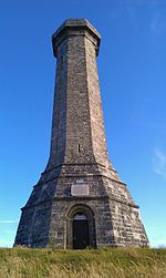
The Hardy Monument is a 72-foot-high (22 m) monument on the summit of Black Down in Dorset, erected in 1844 by public subscription in memory of Vice Admiral Sir Thomas Hardy, flag captain of Admiral Lord Nelson at the Battle of Trafalgar. Admiral Hardy lived in Portesham and his family owned the Portesham estate which stretched from the middle of Portesham to Black Down. The site for the monument was chosen because the Hardy family wanted a monument which could be used as a landmark for shipping. The monument has been shown on navigational charts since 1846 and is visible from a distance of 60 miles (97 km). The monument is situated on Black Down, a hill overlooking the English Channel near Portesham in Dorset, England, on the road between Abbotsbury and Martinstown. It was restored in 1900 by his descendants and bought in 1938 by the National Trust for the sum of £15. The monument was designed to look like a spyglass, as Admiral Hardy would have used on board ship. Its eight corners are aligned with the compass points. Viewed from the ground the corner to the right of the lightning conductor points due south. The bench mark on the northwest face denotes the altitude of Black Down at 780 feet (240 m). From the top of the monument at a height of 850 feet (260 m) above sea level it is possible on a clear day to see the coast from Start Point, Devon to St. Catherine's Point on the Isle of Wight, both of which are 56 miles (90 km) distant. To the north can be seen Pen Hill in the Mendip Hills which is 38 miles (61 km) away. The monument was closed to the public in 2009 when major renovation work was required. This work was completed in January 2012. To date, the monument is regularly opened during the peak season, where visitors can climb the 120 steps to the viewpoint at the top. The heathland area around the monument was in 1984 designated a Site of Special Scientific Interest, when the Nature Conservancy Council decided that the geology of the area was very rare. The monument was designated as a Grade II listed building in 1956.Adjacent to the monument is a stone seat erected in memory of Lt Col William Digby Oswald who was killed on the Somme in 1916.