place

Langton Herring

Dorset geography stubsVillages in Dorset
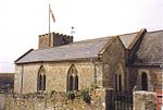
Langton Herring, parish church of St. Peter geograph.org.uk 516409

Langton Herring is a village and civil parish in the county of Dorset in South West England. It lies about 5 miles (8.0 km) north-west of the coastal resort town of Weymouth. It is "prudently set on a ridge above the Fleet", the Fleet being a brackish lagoon behind Chesil Beach. Dorset County Council estimate that in 2013 the population of the civil parish was 120. In the 2011 census the population of the parish combined with the small parish of Fleet to the south was 240.The name of the village comes from the Old English 'Lang + tun' meaning 'long farmstead or estate' with the 13th Century 'Harang' family affix, from their time as Lords of the Manor. Literature in the church records that all the men of Langton Herring returned from both World Wars, making it one of only a handful of doubly Thankful Villages in the country, and the only village in Dorset to be spared fatalities in the Great War. Just over half a mile to the east of the village, by the B3157 road, is Langton Cross, a medieval stone monolith, which is missing the top arm.Langton Herring has one public house the 'Elm Tree Inn', a historic building dating back approximately 400 years.

Excerpt from the Wikipedia article Langton Herring (License: CC BY-SA 3.0, Authors, Images).

Langton Herring
Church Hill,

Geographical coordinates (GPS) Address Nearby Places
placeShow on map

Wikipedia: Langton HerringContinue reading on Wikipedia

Geographical coordinates (GPS)

Latitude Longitude
N 50.64075 ° E -2.54677 °
placeShow on map

Address

Church Hill
DT3 4HU , Langton Herring
England, United Kingdom
mapOpen on Google Maps

Langton Herring, parish church of St. Peter geograph.org.uk 516409
Share experience

Nearby Places

Fleet, Dorset
Fleet, Dorset

Fleet is a small, scattered village and civil parish in south Dorset, England, situated approximately 2.5 miles (4.0 km) west of Weymouth. It consists of the small settlements of East Fleet, West Fleet, Fleet House, and Fleet Common, all of which are close to the shore of The Fleet, a brackish lagoon behind Chesil Beach. The name "Fleet" is derived from fleot, Old English for an inlet or estuary. Dorset County Council estimated that the population of the civil parish was 60 in 2013.The Great Storm of 1824 caused waves to breach Chesil Beach, and many of the buildings in the village were destroyed, including the nave of the original parish church. An eye-witness described the event: At six o'-clock on the morning of the 23rd I was standing with other boys by the gate near the cattle pound when I saw, rushing up the valley, the tidal wave, driven by a hurricane and bearing upon its crest a whole haystack and other debris from the fields below. We ran for our lives to Chickerell, and when we returned found that five houses had been swept away and the church was in ruins. A new church, Holy Trinity, was built a short distance inland and only the chancel of the old one stands today.J. Meade Falkner's smuggling novel Moonfleet is set in the village. There is a brass memorial to Falkner in the old church, together with brass plate memorials to members of the Mohun family whose name was used in the novel. Moonfleet Manor Hotel is a Georgian building in the west of the parish on the shore of The Fleet, previously called Fleet House. The bouncing bomb, designed by Barnes Wallis and immortalised in the film The Dam Busters, was tested on the waters of the Fleet.