Tatuanui
Matamata-Piako DistrictPopulated places in WaikatoUse New Zealand English from March 2020
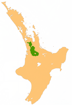
Tatuanui is a settlement and rural community in the Matamata-Piako District and Waikato region of New Zealand's North Island. It is located north-east of Morrinsville, south-west of Te Aroha, Waihou and Waitoa, and north of Ngarua, at the intersection of State Highway 26 and State Highway 27. The intersection was converted to a roundabout between June and December 2011 for safety reasons.
Excerpt from the Wikipedia article Tatuanui (License: CC BY-SA 3.0, Authors).Tatuanui
Tātuanui Roundabout,
Geographical coordinates (GPS) Address Nearby Places Show on map
 Continue reading on Wikipedia
 Geographical coordinates (GPS)
| Latitude | Longitude |
|---|---|
| N -37.621545 ° | E 175.595736 ° |
Address
Tātuanui Roundabout
Tātuanui Roundabout
Waikato, New Zealand
Open on Google Maps