place

Radio Waikato

Defunct radio stations in New ZealandMass media in New Zealand stubsOceania radio station stubsRadio stations disestablished in 1988Radio stations established in 1971
Radio stations in New ZealandUse New Zealand English from May 2018

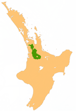
Radio Waikato was a radio station in Hamilton on 954 kHz AM. The station was first started in 1971 as New Zealand's third privately owned station, the station originally broadcast on 930AM but moved to 954AM in 1978 after New Zealand's AM band frequency spacing was adjusted from 10 kHz to 9 kHz. In 1986 Radio Waikato changed to a country music format and was renamed Country Gold - Waikato 954. In 1988 the station's frequency was sold to Radio Pacific and was then used to broadcast Radio Pacific into the Waikato region with originally local programming but later networked programming from Radio Pacific in Auckland.

Excerpt from the Wikipedia article Radio Waikato (License: CC BY-SA 3.0, Authors).

Radio Waikato
Calle Cartagena, Alcantarilla Cañada Hermosa

Geographical coordinates (GPS) Address Website Nearby Places
placeShow on map

Wikipedia: Radio WaikatoContinue reading on Wikipedia

Geographical coordinates (GPS)

Latitude Longitude
N -37.7227 ° E 175.4607 °
placeShow on map

Address

Casa de Cayitas (Casa de la Inquisición;Casa del Santo Oficio)

Calle Cartagena
30820 Alcantarilla, Cañada Hermosa
España
mapOpen on Google Maps

Website
regmurcia.com

linkVisit website

Share experience

Nearby Places

Waitakaruru Stream
Waitakaruru Stream

The Waitakaruru Stream is a major tributary of the Piako River, within the Waikato region of New Zealand's North Island. It should not be confused with the similarly named Waitakaruru River, which is also in the Waikato Region. The Waitakaruru Stream has its origin in the Te Miro-Tahuroa Hills south of Morrinsville, within the Waikato District. Initially the stream flows south and south-west through Scotsman's Valley before turning northwards at Tauwhare flowing roughly parallel to the Pakaroa Range as it passes the boundary of Eureka before entering the Matamata-Piako District. The stream passes through the settlement of Motumaoho, progressively turning a more easterly direction towards Morrinsville, where it has a 1.8 km (1.1 mi) walkway beside it and converges with the larger Piako River on southern outskirts of the town. The stream catchment is highly modified by agriculture, ranging from sheep, beef and dairy farming. Parts of the middle catchment are prone to minor flooding due to a natural constriction in the stream channel between Eureka and Motumaoho. The stream is part of the Eureka Drainage Scheme, managed by the Waikato Regional Council. The Waitakaruru Stream is notable in that it forms part of the catchment boundary between the Piako River catchment and the Waikato River catchment. The Piako River drains into the Firth of Thames, and ultimately the Pacific Ocean, while the Waikato River drains into the Tasman Sea. The bordering sub-catchment which feeds the Waikato River is the Mangaonua Stream. It also has a tributary named Waitakaruru Stream. Near its source, in the Scotsman Valley area, the stream has short- and long-fin eels, common bully, torrentfish and koura.

Waikato
Waikato

The Waikato () is a region of the upper North Island of New Zealand. It covers the Waikato District, Waipa District, Matamata-Piako District, South Waikato District and Hamilton City, as well as Hauraki, Coromandel Peninsula, the northern King Country, much of the Taupō District, and parts of the Rotorua Lakes District. It is governed by the Waikato Regional Council. The Waikato stretches from Coromandel Peninsula in the north, to the north-eastern slopes of Mount Ruapehu in the south, and spans the North Island from the west coast, through the Waikato and Hauraki to Coromandel Peninsula on the east coast. Broadly, the extent of the region is the Waikato River catchment. Other major catchments are those of the Waihou, Piako, Awakino and Mokau rivers. The region is bounded by Auckland on the north, Bay of Plenty on the east, Hawke's Bay on the south-east, and Manawatū-Whanganui and Taranaki on the south. Waikato Region is the fourth largest region in the country in area and population: It has a land area of 23,901.09 km2 (9,228.26 sq mi) and a population of 536,200 (June 2024). The region encompasses all or part of eleven territorial authorities, the most of any region of New Zealand. It is centred on the Waikato which consists of Waikato District, Matamata-Piako District, Waipa District, South Waikato District and Hamilton City. In descending order of land area the eleven territorial authorities are Taupō District (part), Waikato District, Waitomo District (part), Thames-Coromandel District, Ōtorohanga District, South Waikato District, Matamata-Piako District, Waipa District, Hauraki District, Rotorua Lakes District (part), and Hamilton City.