place

Bronschhofen railway station

Pages with no open date in Infobox stationRailway stations in the canton of St. GallenTHURBO stations
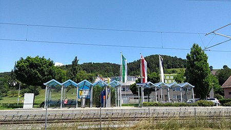
Bronschhofen railway station

Bronschhofen railway station (German: Bahnhof Bronschhofen) is a railway station in the village of Bronschhofen, part of the municipality of Wil, in the Swiss canton of St. Gallen. It is an intermediate stop on the standard gauge Wil–Kreuzlingen line of THURBO. The station is a request stop.

Excerpt from the Wikipedia article Bronschhofen railway station (License: CC BY-SA 3.0, Authors, Images).

Bronschhofen railway station
Industriestrasse,

Geographical coordinates (GPS) Address Nearby Places
placeShow on map

Wikipedia: Bronschhofen railway stationContinue reading on Wikipedia

Geographical coordinates (GPS)

Latitude Longitude
N 47.475 ° E 9.035 °
placeShow on map

Address

Industriestrasse
9551 , Kreis Wil - Land (Bronschhofen und Rossrüti)
St. Gallen, Switzerland
mapOpen on Google Maps

Bronschhofen railway station
Share experience

Nearby Places

Adula Alps
Adula Alps

The Adula Alps, also known as the West Graubünden and Misox Alps, are a western Alpine mountain group, the part of the Lepontine Alps from the Lukmanier and St Gotthard Passes to the Splügen Pass. They lie mostly in Switzerland, in the Cantons of Ticino, Graubünden, and Uri, and partly in Italy, in the province of Sondrio in Lombardy, stretching south to Lake Como. They form subsection 10B of the Alps, according to the Partizione delle Alpi, and subsection 10 III, according to the unified orographic classification of the Alps by Sergio Marazzi (SOIUSA). A string of mountains of the Adula stand on the international border between Switzerland and Italy, including Pizzo Tambò, Piz di Pian, Cima de Pian Guarnei (Pizzo Quadro), Cime di Val Loga, Piz Tamborello, Piz della Forcola, Pizzaccio, and Cima dello Stagn, while Pizzo Ferré is near the border on the Italian side. The mountain guides of the Swiss Alpine Club do not lead climbers in groups for the Adula Alps, but attach parts of them to other sections. The highest peak is the Rheinwaldhorn (3402 metres, 11,161 ft), which in Italian is called the Adula, giving the range its name.The main valleys are Val Malvaglia, which drains into the lower Blenio Valley, and three others draining south out of the Adula Alps, which are, from west to east, Val Calanca, Valle Mesolcina, and Valle Spluga (or San Giacomo).The creation of an Adula National Park was planned by Switzerland for sixteen years, from 2000. It would have become only the second in the country, after the Swiss National Park, but in November 2016 the inhabitants voted against it.