place

Francis Lake (California)

El Dorado County, California, geography stubsEldorado National ForestLake TahoeLakes of CaliforniaLakes of El Dorado County, California
Lakes of Northern CaliforniaLakes of the Sierra Nevada (United States)
Francis Lake
Francis Lake

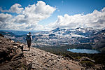
Francis Lake is a small backcountry lake in the Sierra Nevada mountain range, to the west of Lake Tahoe in the Eldorado National Forest. There are no trails to this lake. This lake is very near Loon Lake.

Excerpt from the Wikipedia article Francis Lake (California) (License: CC BY-SA 3.0, Authors, Images).

Francis Lake (California)
Ice House Road,

Geographical coordinates (GPS) Address Nearby Places
placeShow on map

Wikipedia: Francis Lake (California)Continue reading on Wikipedia

Geographical coordinates (GPS)

Latitude Longitude
N 38.992222222222 ° E -120.33972222222 °
placeShow on map

Address

Ice House Road

California, United States
mapOpen on Google Maps

Francis Lake
Francis Lake
Share experience

Nearby Places

Hell Hole Reservoir
Hell Hole Reservoir

Hell Hole Reservoir is an artificial, crescent-shaped lake in the Sierra Nevada mountain range 10 miles (16 km) west of Lake Tahoe in California, United States. The lake is about 3.5 miles (5.6 km) long when at full capacity. The lake was created in 1966 with the completion of Lower Hell Hole Dam across the Rubicon River, a major tributary of the Middle Fork of the American River. Hell Hole is named for a deep canyon which is now under the waters of the lake. How the canyon came to be named Hell Hole is a combination of folklore and speculation. An early author, George Wharton James (1858–1923), visited the canyon in 1913. He imagined that one of the miners seeking riches in the 1860s, in what was then called "Squaw Valley", now Olympic Valley must have thought it "a hell of a hole to get into or out of", but admitted his source for the place name was more speculative than the anonymous miner's chances for riches in the area. James' guide for the 1913 camping expedition to Hell Hole was Bob Watson, a well-known camping guide who operated in the Lake Tahoe Region from the 1880s into the first decades of the 20th century. Watson may have been the source of the story as he sought to entertain and edify his paying clients with tales of local history. James attributed much of the local lore to Watson. The United States Board on Geographic Names attributes the first use of the name "Hell Hole" to a United States Geological Survey map of 1894. The board was created in 1890, so previous uses of the name on federal government maps are possible. James reported finding a natural lake near the Hell Hole chasm known as Bear Lake, which would have been drowned by the reservoir. He also described Hell Hole in terms that bely the colorful name: "Hell Hole? Then give me more of it," he wrote. The author reported his pleasure of the canyon was derived from its rugged nature that precluded human exploitation: Logging, mining, water development and road building, evident in other portions of the Lake Tahoe region. It was "a paradise of delightful surprises," he wrote.

Union Valley Reservoir

Union Valley Reservoir is a reservoir in eastern El Dorado County, California, about 20 miles (32 km) northeast of Placerville. The 277,000 acre-feet (342,000,000 m3) lake is in Eldorado National Forest in the Sierra Nevada at an elevation of 4,870 feet (1,480 m). It was formed in 1963 (1963) by the 453-foot (138 m) high earth and rockfill Union Valley Dam on Silver Creek, which is a tributary of the American River. The reservoir is part of the Upper American River Project of the Sacramento Municipal Utility District, a public electric utility, which operates the dam and many other dams in the area. Recreation such as boating, fishing and camping is available there. It stores snow melt runoff during the spring and releases it during the summer when electrical demand is greatest to a chain of hydroelectric power plants downstream. Union Valley Powerhouse at the base of the dam has a capacity of 46.7 MW and is operated as a peaking power plant, supplying electricity during times of the greatest demand. Consumptive rights to the water itself are held by the City of Sacramento, California. The reservoir is fed by Big Silver Creek, Jones Fork Silver Creek, Tells Creek, Wench Creek and the outflows of Robbs Peak and Jones Fork powerhouses. Jones Fork Powerhouse is not on Jones Fork Silver Creek but instead conveys water from Ice House Reservoir. Robbs Peak Powerhouse gets its water from the Middle Fork American River headwaters, by way of Loon Lake Reservoir, and small reservoirs on Gerle Creek and South Fork Rubicon River. Downstream from Union Valley Dam, Silver Creek waters are largely diverted through two additional powerhouses below small reservoirs before joining the South Fork American River a few miles north of Pollock Pines, California. Silver Creek was an intermittent creek before the development of Union Valley Reservoir and the diversions from the Middle Fork American River.