place

Union Literary Institute

1846 establishments in Indiana1880 disestablishments in IndianaAfrican-American history of IndianaAfrican-American magazinesAmerican manual labor schools
Antebellum educational institutions that admitted African AmericansBuildings and structures in Randolph County, IndianaEducation in Randolph County, IndianaEducational institutions disestablished in 1880Educational institutions established in 1846Tourist attractions in Randolph County, IndianaUnderground Railroad in Indiana
Union Literary Institute

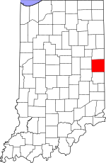
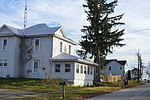
The Union Literary Institute, located in rural Randolph County, Indiana, at 8605 East County Road 600 South, Union City, Indiana (at its founding, "two miles east of Spartanburg"), was a historic school founded in 1846 primarily for blacks by abolitionist Quakers and free blacks in three local communities. Only white students were allowed to attend the public schools in the state. The term "literary institute" at the time meant a non-religious school. This school was among the handful in the United States of the time that admitted both black and white students; it was the first in Indiana. The school closed in 1864 during the Civil War, when its only teacher enlisted in the United States Colored Troops. The students published a magazine from 1863-1864, which included articles by adults. The school re-opened after the war, operating until 1880; it closed because of declining enrollment. In 1924, after three decades of court challenges, the state acquired the building and the remaining 120 acres of the original site. The county had operated the structure as a segregated public school in the late nineteenth century. In the early 20th century, the structure was converted for use as a storage barn. In 2016 a historical marker was erected at the former school, noting its valuable history. It is within the Ohio River National Freedom Corridor.

Excerpt from the Wikipedia article Union Literary Institute (License: CC BY-SA 3.0, Authors, Images).

Union Literary Institute
East 600 S,

Geographical coordinates (GPS) Address Nearby Places
placeShow on map

Wikipedia: Union Literary InstituteContinue reading on Wikipedia

Geographical coordinates (GPS)

Latitude Longitude
N 40.077222222222 ° E -84.816388888889 °
placeShow on map

Address

East 600 S 8619
47390
Indiana, United States
mapOpen on Google Maps

Union Literary Institute
Share experience

Nearby Places

Hoosier Hill
Hoosier Hill

Hoosier Hill is the highest natural point in the U.S. state of Indiana with a claimed elevation of 1,257 feet (383 meters) above sea level. Hoosier Hill's claimed elevation is based on SRTM digital elevation data which is now considered to be outdated. Using newer elevation tools such as USGS's 3DEP, the top of Hoosier Hill is closer to 1,255.48 feet (382.67 meters) above sea level. Hoosier Hill is in the rural area of Franklin Township, Wayne County to the northwest of Bethel. The nearest intersection to the high point is Elliot Road and County Line Road. The nearest major landmark is Interstate 70 and Richmond 11 miles (18 km) to the south. Hoosier Hill sits on private property owned by Kim E. Goble. The high point sits in a forested area surrounded by farmland. In 2005, an Eagle Scout candidate named Kyle Cummings (Troop 820 from Lakeside Park, Kentucky), in cooperation with the property owner, built a trail, sign and picnic area at the high point.Geologically, the hill sits in the Dearborn Upland, an area of high terrain in southeast Indiana that sits on top of the geologic structure known as the Cincinnati Arch. However, Hoosier Hill is located in a portion of the upland buried underneath glacial debris known as the Tipton Till Plain. As a result, while the average elevation of this upland region is 1100±100 feet above sea level, the topographic relief is gentle where the "hill" is no more than 30 feet higher than the surrounding landscape of gently rolling farmland. While the high topography seen at Brown County State Park, which sits in the Norman Upland in south central Indiana, can be mistaken to be a high point (where relief is 400–500 feet from valley to hilltop), the elevations of hilltops ranges from 800 to 1050 feet. A.H. Marshall was the first person to successfully climb each U.S. state highpoint. He completed the task in 1936 after standing atop Hoosier Hill.According to the local government, the wooden sign with the words, "INDIANA'S HIGHEST POINT" would frequently be stolen, so in 2016 the wooden sign was permanently replaced by an engraved boulder.