place

Biddulph Grange Country Park

BiddulphCountry parks in Staffordshire
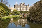
Biddulph Grange Country Park 2019 029

Biddulph Grange Country Park is a country park in Biddulph, UK. It was originally part of Biddulph Grange.

Excerpt from the Wikipedia article Biddulph Grange Country Park (License: CC BY-SA 3.0, Authors, Images).

Biddulph Grange Country Park
Woodland Walk, Staffordshire Moorlands

Geographical coordinates (GPS) Address Nearby Places
placeShow on map

Wikipedia: Biddulph Grange Country ParkContinue reading on Wikipedia

Geographical coordinates (GPS)

Latitude Longitude
N 53.129166666667 ° E -2.1555555555556 °
placeShow on map

Address

Woodland Walk

Woodland Walk
ST8 7TA Staffordshire Moorlands
England, United Kingdom
mapOpen on Google Maps

Biddulph Grange Country Park 2019 029
Share experience

Nearby Places

Knypersley Hall

Knypersley Hall is an 18th-century Georgian style country mansion at Biddulph, Staffordshire, England. It is protected as a Grade II* Listed building. After falling into a state of disrepair it was partially subdivided into residential apartments, although the Hall was not wholly restored at this point and was falling into further disrepair. However, the current owner has restored, repaired and divided into three separate residential dwellings - Knypersley Hall (the grand hall proper), East View and West View which complement the remainder of the original buildings which were part of the original Hall Estate (The Chapel, Rose Cottage, The Workshop and The Coach House). The Manor of Knypersley was held by the de Knypersley family from ancient times, until Katherine de Knypersley, heiress to the estates, married Thomas Bowyer late in the 14th century. Several branches of the Bowyer family became Bowyer baronets. In the 18th century the old manor house was replaced by the Bowyers. The substantial three storey, seven bay mansion then erected was remodelled about 1847 when the top storey was removed. The Bowyer Baronetcy became extinct with the death of the 4th Baronet in 1702. His daughter and heiress Dorothy married Sir Thomas Gresley Bt in 1719. See Gresley baronets. The Gresleys sold the estate in about 1809 to the noted horticulturist John Bateman, who developed the gardens but who in about 1840 moved to begin a larger project with his son James Bateman at Biddulph Grange. The Grade II listed stable block has also been converted into dwellings.

Gritstone Trail
Gritstone Trail

The Gritstone Trail, or Cheshire Gritstone Trail, is a 35-mile (56 km) long-distance footpath in England which follows the most westerly hills of the Peak District from Disley Station to Mow Cop, and on via the Macclesfield Canal to Kidsgrove Station. Managed by Cheshire East (although partly in Staffordshire), the trail involves 5,900 feet (1,800 m) of ascent and is mainly outside the National Park. There are other routes in the Peak District referred to as a “Gritstone Trail” but they are less well established. The trail connects the accessible and popular outdoor destinations of Lyme Park, White Nancy, Tegg's Nose and The Cloud, and the high sections of the trail are all notable for gritstone scenery and extensive views over the Cheshire Plain. Apart from the café at Tegg's Nose, there are no facilities on the route. Most through hikers take 3 days (stopping at Macclesfield and Congleton) to complete the trail, traditionally (but for no particular reason) walked north to south, though the trail is more often used for shorter walks. The record in the annual Gritstone Grind (run south to north) is just under 5 hours. Footpaths in Cheshire are marked with yellow discs indicating the direction of continuation, with Gritstone Trail Markers containing a footprint inscribed with a 'G'. There are also many wooden fingerposts with 'Gritstone Trail' engraved. An unofficial extension from Kidsgrove to the mainline railway station at Stoke-on-Trent, The Kidsgrove to Stoke Ridgeway, is available as a free ebook.