Maresha

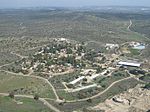
Tel Maresha (Hebrew: תל מראשה) is the tell (archaeological mound) of the biblical Iron Age city of Maresha, and of the subsequent, post-586 BCE Idumean city known by its Hellenised name Marisa, Arabised as Marissa (ماريسا). The tell is situated in Israel's Shephelah region, i.e. in the foothills of the Judaean Mountains, about 2 kilometres (1.2 mi) southeast of Beit Gubrin. Maresha was first excavated in 1898–1900 by the British archaeologists Bliss and Macalister on behalf of the Palestine Exploration Fund and again after 1989 by Israeli archaeologist Amos Kloner on behalf of the Israel Antiquities Authority. Excavations revealed that Maresha was inhabited (not necessarily continuously) during the Iron Age, the Persian period, and the Hellenistic period. Most of the artifacts of the British excavation are to be found today in the Istanbul Archaeology Museums. This site is now protected as part of Beit Guvrin-Maresha National Park and its burial caves are recognized by UNESCO as a World Heritage Site.
Excerpt from the Wikipedia article Maresha (License: CC BY-SA 3.0, Authors, Images).Maresha
35, Yoav Regional Council
Geographical coordinates (GPS) Address Nearby Places Show on map
Geographical coordinates (GPS)
| Latitude | Longitude |
|---|---|
| N 31.593055555556 ° | E 34.898333333333 ° |
Address
35
Yoav Regional Council
South District, Israel
Open on Google Maps


