Ma Wat River
FanlingHong Kong geography stubsRivers of Hong Kong

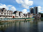
The Ma Wat River (Chinese: 麻笏河) is a river in Fanling, northern New Territories, Hong Kong. Its source lies at Kau Lung Hang Shan. The river flows northwards towards Fanling, staying near the eastern industrial areas. It empties into the Ng Tung River near Kan Lung Tsuen.
Excerpt from the Wikipedia article Ma Wat River (License: CC BY-SA 3.0, Authors, Images).Ma Wat River
Fanling Bypass, North District
Geographical coordinates (GPS) Address Nearby Places Show on map
 Continue reading on Wikipedia
 Geographical coordinates (GPS)
| Latitude | Longitude |
|---|---|
| N 22.4891 ° | E 114.1472 ° |
Address
粉嶺繞道 Fanling Bypass
Fanling Bypass
North District
Hong Kong, China
Open on Google Maps