Monkswood Valley

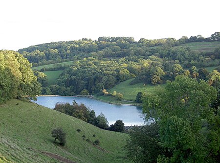
Monkswood Valley (grid reference ST754710) is a 30.7-hectare biological Site of Special Scientific Interest (SSSI) near the village of Cold Ashton, South Gloucestershire, notified in 1990.Monkswood Reservoir, built in 1896 and now owned by Wessex Water, is situated in the valley of the SSSI. The SSSI is woodland and grassland on the sloping land north and south of the reservoir and its tributary.The woodlands contain Fraxinus excelsior – Acer campestre – Mercurialis perennis (Ash–field Maple–Dog's Mercury) areas, which has limited distribution in Great Britain.The SSSI has four areas: Monk Woods, Hunterwick Wood & Hartley Wood, Frys Farm and Valley. St. Catherine's Valley SSSI is immediately to the north-east.The Gloucestershire–Somerset border runs through the reservoir and SSSI. The SSSI is adjacent to the Limestone Link long-distance footpath.
Excerpt from the Wikipedia article Monkswood Valley (License: CC BY-SA 3.0, Authors, Images).Monkswood Valley
Leigh Lane,
Geographical coordinates (GPS) Address Nearby Places Show on map
Geographical coordinates (GPS)
| Latitude | Longitude |
|---|---|
| N 51.43746 ° | E -2.3553 ° |
Address
Leigh Lane
Leigh Lane
BA1 8HQ
England, United Kingdom
Open on Google Maps


