place

Hurstbourne Tarrant

Hampshire geography stubsVillages in Hampshire
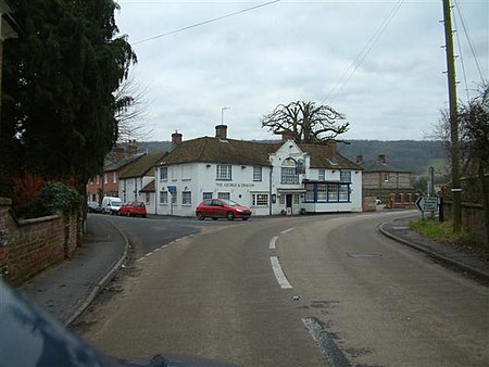
The George and Dragon geograph.org.uk 99906

Hurstbourne Tarrant is a village and civil parish in Hampshire, England. It lies to the north of the county in the Test Valley. The Tarrant part of the name originates from 1226, when the village was given to the Cistercian Tarrant nunnery. The civil parish includes the village of Ibthorpe.During the Second World War, Hurstbourne Tarrant was the decoy site for RAF Andover, the headquarters of RAF Maintenance Command. This was one of four airfields in Hampshire to be given a decoy site in 1940, to deceive enemy aircraft into attacking a spurious target. The decoy site at Hurstbourne Tarrant was a type 'K' decoy site with fake aircraft and buildings. From September 1940, fake machine gun posts were added to Hurstbourne Tarrant.The famous American Victorian/Edwardian artist Anna Lea Merritt lived in the village for many years. William Cobbett declared Hurstbourne Tarrent and its location as worth going miles to see with beauty at every turn. He referred to it in his book Rural Rides (1830; but serialised from 1822) as Uphusband.

Excerpt from the Wikipedia article Hurstbourne Tarrant (License: CC BY-SA 3.0, Authors, Images).

Hurstbourne Tarrant
The Dene (Newbury Road), Test Valley Hurstbourne Tarrant

Geographical coordinates (GPS) Address Nearby Places
placeShow on map

Wikipedia: Hurstbourne TarrantContinue reading on Wikipedia

Geographical coordinates (GPS)

Latitude Longitude
N 51.27749 ° E -1.451262 °
placeShow on map

Address

The Dene (Newbury Road)

The Dene (Newbury Road)
SP11 0AG Test Valley, Hurstbourne Tarrant
England, United Kingdom
mapOpen on Google Maps

The George and Dragon geograph.org.uk 99906
Share experience

Nearby Places

Little London, Andover, Hampshire

Little London is a hamlet and civil parish which lies 3.5 miles north of Andover in Hampshire, England. The hamlet is in the parish of Smannell (where the 2011 Census population was included. ) and has 53 houses. One side of the village has a number of original flint and mortar and thatch-roofed cottages whilst Ridges View is 1960s ex local authority houses. The pub (Horse and Jockey) closed in the 80's and the Post Office also has gone. The village is set in a beautiful location nestled in a gentle valley in Northern Hampshire. It is surrounded by farmland and has woodland at the top of the village (Doles Wood) and has a single road that runs to Frenches Farm. There are two other 'roads' - Big Street and Little Street (which is now a footpath). The village dates back to around the late 17th century. Its name suggests that the inhabitants came from London - possibly post the outbreak of plague in 1665 or after the fire of 1666 and settled in the fields outside Andover. There have been over one hundred Little Londons (currently there are 12) in the UK and another one just 12 miles away near Kingsclere, Hampshire. There is a village well in Little Street that has been capped and there are several other wells on private properties in the village. Annually there is a Summer Village Fete, annual Christmas light switch on, quiz, and a fireworks night. These are mostly organised by the Little London Playing Field Association. A newly built German all glass Hauf Haus has been recently built and overlooks the village surroundings. In terms of wildlife, the village has a range of bats, birds including night jars, nuthatches and buzzards, and several different types of deer. In 2011/2012 the village received high speed, fibre based, broadband services after a successful campaign. Working with Hampshire County Council FTTC capabilities were delivered providing speeds up to 40Mbit/s. This scheme was retired in 2018 and now Vodafone and BT can provide up to 76mbits.