Hanwood
EngvarB from September 2013Villages in Shropshire

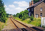
Hanwood is a large village in Shropshire, England. It is located 3 miles (4.8 km) SW of Shrewsbury town centre, on the A488 road. The A5 is only a mile away. The Cambrian Line runs through the village but there is no longer a railway station here. It was closed in 1964, as a result of the Beeching Axe. The nearest working passenger station is at Shrewsbury. The Rea Brook flows through the village and the village is laid along the floor of a small valley. The village forms the main of the civil parish of Great Hanwood.
Excerpt from the Wikipedia article Hanwood (License: CC BY-SA 3.0, Authors, Images).Hanwood
Church Lane,
Geographical coordinates (GPS) Address Nearby Places Show on map
Geographical coordinates (GPS)
| Latitude | Longitude |
|---|---|
| N 52.681 ° | E -2.824 ° |
Address
Church Lane
SY5 8LL , Great Hanwood
England, United Kingdom
Open on Google Maps


