place

Hanwood railway station

Disused railway stations in ShropshireFormer Great Western Railway stationsFormer London and North Western Railway stationsPages with no open date in Infobox stationRailway stations in Great Britain closed in 1960
Railway stations in Great Britain opened in 1861West Midlands (region) railway station stubs
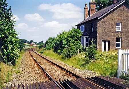
Hanwood station remains geograph 3600263 by Ben Brooksbank

Hanwood railway station was a station in Hanwood, Shropshire, England. The station was opened in 1861 and closed to passengers in 1960, and to goods traffic in 1964.

Excerpt from the Wikipedia article Hanwood railway station (License: CC BY-SA 3.0, Authors, Images).

Hanwood railway station
A488,

Geographical coordinates (GPS) Address Nearby Places
placeShow on map

Wikipedia: Hanwood railway stationContinue reading on Wikipedia

Geographical coordinates (GPS)

Latitude Longitude
N 52.6815 ° E -2.8284 °
placeShow on map

Address

A488
SY5 8LR , Great Hanwood
England, United Kingdom
mapOpen on Google Maps

Hanwood station remains geograph 3600263 by Ben Brooksbank
Share experience

Nearby Places

Annscroft
Annscroft

Annscroft is a small village in Shropshire, England. It is located on the Shrewsbury to Longden road, approximately 4 miles from Shrewsbury, with nearby hamlets Arscott and Hook-a-Gate. The village is a linear settlement, laid along the one road, and is in the civil parish of Longden. Many of the houses were 'squatter cottages' built in the 19th century to house miners working in the local collieries, which closed by 1940.There is a church at the village's north-east end: Christ Church (C of E) was built in 1868–69, by Shrewsbury architect John Laurence Randall at a cost of £1,400, raised by subscription. It is of rubble-stone with sandstone dressings, in Early English style. The church contains three war memorials: a brass plaque on the south wall of the nave in memory of Trooper William Hulston who was killed in the Boer War of 1899-1902, a marble plaque in the chancel to 18 men who died through serving in World War I and an electric blower organ with plaque to 9 men who died as a result of World War II. The churchyard contains Commonwealth war graves of a Royal Welsh Fusiliers soldier of World War I and a Royal Air Force airman of World War II.Half a mile north-west of the village is Moat Hall, a disguised timber-framed house built for the Berington family in about 1600, jetty underbuilt in brick. It gave its name to the Moat Hall Colliery, the largest mine in the vicinity, which was merged under one company with the colliery at Hanwood in 1921 and where coal ceased to be lifted in 1931.The village is home to bus and coach operator Minsterley Motors, South Shropshire Hunt Kennels, Stoneyford Riding School and The Farriers Business Park.