Johannesburg

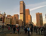
Johannesburg ( joh-HAN-iss-burg, US also -HAHN-, Afrikaans: [jʊəˈɦanəsbœrχ]; Zulu and Xhosa: eGoli [ɛˈɡɔːli]) (colloquially known as Jozi, Joburg, Jo'burg or "The City of Gold") is the most populous city in South Africa with 4,803,262 people, and is classified as a megacity; it is one of the 100 largest urban areas in the world. It is the provincial capital and largest city of Gauteng, which is the wealthiest province in South Africa. Johannesburg is the seat of the Constitutional Court, the highest court in South Africa. Most of the major South African companies and banks have their head offices in Johannesburg. The city is located within the mineral-rich Witwatersrand hills, the epicentre of the international-scale mineral, gold and (specifically) diamond trade. Johannesburg was established in 1886, following the discovery of gold, on what had been a farm. Due to the extremely large gold deposits found along the Witwatersrand, within ten years, the population had grown to over 100,000 inhabitants. A separate city from the late 1970s until 1994, Soweto is now part of the Greater Johannesburg metropolitan area. An acronym for "South-Western Townships", Soweto was organised initially as a collection of nondescript settlements on the outskirts of the city, populated mostly by African labourers working in the gold mining industry. Soweto, although eventually incorporated into Johannesburg, had been explicitly separated as a residential area for blacks only—no whites allowed—who were not permitted to live in other "white-designated" areas of Johannesburg. Another region, Lenasia, is predominantly populated by English-speaking Indo-South Africans (people of Indian and South Asian descent). These areas were, in previous decades, designated as non-white areas, in accordance with the segregationist policies of the time—known as apartheid. It would go on to be one of the host cities of the official tournament of the 2010 FIFA World Cup—and it hosted the final. The metropolis is an alpha global city, as listed by the Globalization and World Cities Research Network. In 2019, the population of the city of Johannesburg was 5 635 127, making it the most populous city in South Africa. In the same year, the population of metro Johannesburg's urban agglomeration was put at 8 000 000. Land area of the municipal city (1,645 km2 or 635 sq mi) is large in comparison with those of other major cities, resulting in a moderate population density of 2,364 per square kilometre (6,120/sq mi).
Excerpt from the Wikipedia article Johannesburg (License: CC BY-SA 3.0, Authors, Images).Johannesburg
Kruis Street, Johannesburg Johannesburg Ward 124
Geographical coordinates (GPS) Address Nearby Places Show on map
Geographical coordinates (GPS)
| Latitude | Longitude |
|---|---|
| N -26.204444444444 ° | E 28.045555555556 ° |
Address
Kruis Street 41
2001 Johannesburg, Johannesburg Ward 124
Gauteng, South Africa
Open on Google Maps


