place

Tokai Arboretum

Arboreta
Tokai Arboretum Entrance

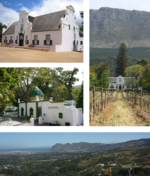
The Tokai Arboretum was the first large-scale silviculture experimental station in Cape Town, South Africa. The area of the main Arboretum, at Tokai Park, is 14 ha. Several adjacent compartments extend the area to 26 ha. The Arboretum was declared a National Monument in 1985, on its 100th anniversary. It contains stands of Eucalyptus and other trees from the original silviculture experiments in South Africa. In the 1990s a Gondwana Garden was created to display the plants typical of the Cape 100 million years ago.The Tokai Arboretum is a collection of trees of different sizes, established without a silvicultural or arboricultural plan (lack of open vistas, swards, shrubberies and beds of flowers to display the trees). Tokai Arboretum has stands of Karri (Eucalyptus diversicolor), Scribbly Gum, Jarrah (Eucalyptus marginata), Redwoods (Sequoioideae), Aleppo Pines (Pinus halepensis), Stone Pines (Pinus pinea) and many other tree species. There are about 28 trees in the main Arboretum with record heights for South Africa. The main Arboretum at Tokai is the oldest wholly government financed arboretum in South Africa. Following the establishment of the main Arboretum, three lesser arboreta were initiated at Tokai Plantation, namely the Paddock Arboretum (on infertile sands of the Cape Flats), the Spekboom Belt Arboretum (on fertile granite slopes) and the Flagstaff Arboretum. The latter was soon abandoned.

Excerpt from the Wikipedia article Tokai Arboretum (License: CC BY-SA 3.0, Authors, Images).

Tokai Arboretum
Tokai Road,

Geographical coordinates (GPS) Address Nearby Places
placeShow on map

Wikipedia: Tokai ArboretumContinue reading on Wikipedia

Geographical coordinates (GPS)

Latitude Longitude
N -34.0596694 ° E 18.4167583 °
placeShow on map

Address

Tokai Manor House

Tokai Road
7806 , Cape Town Ward 71
Western Cape, South Africa
mapOpen on Google Maps

Tokai Arboretum Entrance
Share experience

Nearby Places

Tokai Park
Tokai Park

Tokai Park, previously known as "Tokai Forest", is a small wing, about 600 ha, of the greater Table Mountain National Park in Cape Town, South Africa. Tokai Park is made up of two sections: upper and lower Tokai Park. Lower Tokai Park is flat, and characterized by the threatened Cape Flats Sand Fynbos. Upper Tokai Park is on the slopes of Constantiaberg Mountain, and consists of conservation area as well as the Tokai Arboretum. Upper Tokai Park is characterized by Peninsula Granite Fynbos, Peninsula Sandstone Fynbos and Afromontane Forest and noted for its diversity.Until recently, most of Tokai Park was under plantation. However the lease of Tokai Park by MTO Forestry expires in 2025, and the removal of the last of the commercial plantations has been followed by restoration efforts by South African National Parks and other conservation organisations. Today Tokai Park has over 110 plant species threatened with extinction or extinct in the wild and restored at Tokai. Perhaps the best known example of a species that is extinct in the wild, but which is recovering at Tokai Park is Erica verticillata. More than 350 plant species have already naturally returned. There are now over 440 recorded plant species at Lower Tokai Park according to a species list compiled by scientists. According to William Frederick Purcell's list, there may be over 500 plant species expected.Tokai Park is also a popular recreational area, with walking trails, horse-riding and cycling trails as well as a picnic area. Whilst recreation is regarded by all as an important ecosystem service provided by this park, there has been much contention over shaded walk-ways, with scientists maintaining that shaded recreation is not compatible with Fynbos restoration, and a group of the public who wish to retain the plantations for shaded recreation.

Constantiaberg
Constantiaberg

Constantiaberg is a large, whalebacked mountain that forms part of the mountainous spine of the Cape Peninsula in Table Mountain National Park, Cape Town, South Africa. It lies about 7 km south of Table Mountain, on the southern side of Constantia Nek. The mountain is 927 m high. It is not known who first ascended the peak. Constantiaberg, Devil's Peak and Table Mountain are the highest mountains in the range that stretches from Table Mountain all the way to Cape Point. The range, made up of resistant sandstones of the Table Mountain Group, dominates the southern suburbs of the city on the verge of the Cape Flats. The lower eastern slopes of Constantiaberg are covered by the commercial pine and gum plantations of Tokai forest, and are crisscrossed with hiking trails and gravel roads that are used for harvesting the trees. The forest is popular for walking, running and mountain biking. The western slopes of the mountain overlook the magnificent scenery of Hout Bay. A tarred road leads to the summit of Constantiaberg, where an important VHF mast is located 34°03′17.78″S 18°23′10.77″E. The mast is about 100 m high and is visible for perhaps 80 kilometers in any direction. It was constructed in the 1960s and is used to transmit signals for many local television and radio channels, and also to support cellular networks. The South African Weather Service has a radar installation at the summit. Constantiaberg is home to a variety of bird and plant species. The mountain is covered mainly by fynbos, a botanical biome native to the Western Cape. The specific vegetation type of the mountain is Peninsula Sandstone Fynbos, an endangered vegetation type that is endemic to the city of Cape Town - occurring nowhere else in the world. Elephant's Eye cave, a popular hiking destination, is the mountain's biggest feature after the mast. This is visible near the southern end of the mountain when viewed from the Cape Flats. Elephant's Eye is so named because the eastern profile of the mountain resembles an elephant (the range that continues toward Cape Point being the trunk).