place

Tapada Nacional de Mafra

European protected area stubsGeography of Lisbon DistrictLisbon geography stubsMafra, PortugalPalace of Mafra
Parks in PortugalTourist attractions in Lisbon DistrictWorld Heritage Sites in Portugal
Tapada de Mafra Porta do Codeçal

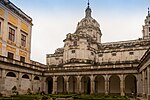
The Tapada Nacional de Mafra was created in Mafra, Portugal, during the reign of king João V, following the building of the Mafra National Palace, as a park for royal and court recreation. Covering over 8 square kilometres, the park holds different species of deer, wild boar, foxes, birds of prey and many others coexisting in an unusually rich and diversified natural habitat. A favourite of the Portuguese monarchy for hunting and other leisure pursuits, the Tapada de Mafra took on a noble connotation that has done much to aid its preservation and continuity. Its natural heritage ensures it is an excellent location for fun environmental awareness and education programmes. The Tapada is also open for walking, mountain biking, horse riding, archery and crossbow shooting activities. On 7 July 2019, the Royal Building of Mafra – Palace, Basilica, Convent, Cerco Garden and Hunting Park (Tapada) was inscribed as a UNESCO World Heritage Site. With an area of 1187 hectares, surrounded by a 21 km long wall, the Tapada de Mafra has a great diversity of animal and plant species and is an area with regulated (paid) access. The area has been divided into three since 1828, with the first 360 hectares under military administration.

Excerpt from the Wikipedia article Tapada Nacional de Mafra (License: CC BY-SA 3.0, Authors, Images).

Tapada Nacional de Mafra
EN 9,

Geographical coordinates (GPS) Address External links Nearby Places
placeShow on map

Wikipedia: Tapada Nacional de MafraContinue reading on Wikipedia

Geographical coordinates (GPS)

Latitude Longitude
N 38.9527769 ° E -9.2965775 °
placeShow on map

Address

Tapada Nacional de Mafra

EN 9
2640-459 (Mafra)
Portugal
mapOpen on Google Maps

linkWikiData (Q7684407)
linkOpenStreetMap (27266287)

Tapada de Mafra Porta do Codeçal
Share experience

Nearby Places

Royal and Venerable Confraternity of the Most Blessed Sacrament of Mafra

The Royal and Venerable Confraternity of the Most Blessed Sacrament of Mafra, alternatively, the Royal and Venerable Brotherhood of the Most Blessed Sacrament of Mafra (Portuguese: Real e Venerável Irmandade do Santíssimo Sacramento de Mafra), is a public association of faithful of the Catholic Church, canonically established in the Basilica of Our Lady and Saint Anthony of Mafra, Portugal. The confraternity is one of the oldest institutions in the municipality of Mafra. It organizes the Corpus Christi solemnity and organizes the four traditional processions of the season of Lent in Mafra: The procession of the Passion of the Lord (Portuguese: Procissão do Senhor Jesus dos Passos); The procession of Penance of the Third Order of Saint Francis (Portuguese: Procissão de Penitência da Ordem Terceira de São Francisco); The procession of Seven Sorrows of Our Lady (Portuguese: Procissão das Sete Dores de Nossa Senhora); and The procession of the Burial of the Lord (Portuguese: Procissão do Enterro do Senhor).Over time, the confraternity has been the custodian of several relics. Those include Louis XV of France's coronation shirt, which he wore for the ceremony in Reims Cathedral.The confraternity also holds the largest collection of processional mannequin-style images (Portuguese: imagens de vestir or imagens de roca) in the country. Some of these are still used for religious processions.Part of the confraternity ceremonies and religious functions take place with the sound of the basilica's six historical pipe organs and two Mafra carillons.

Barreira Megalithic Complex

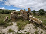
The Barreira Megalithic Complex (Portuguese: Conjunto Megalítico de Barreira) is located in the Sintra municipality in the Lisbon District of Portugal. Situated on a small wooded hill overlooking the village of Odrinhas, site of Roman ruins and an archaeological museum, it consists of about twenty menhirs and other monoliths or megaliths.The site, which is assumed to be a dolmen or cromlech, contains mainly cylindrical stones of varying heights, with the largest being approximately four metres tall. The size of the stones decreased as they became more distant from the central menhir and the megaliths were arranged irregularly depending on the terrain. No carved or painted symbols have been detected, except for a few pairs of small circular cavities, possibly representing eyes. A small number of items have been found to the west of the complex, including flints from the Lower Paleolithic, ceramic fragments and other items from the Neolithic period, and ceramic fragments from the Iron Age, suggesting that the site has been reused over time.The complex was not identified as a megalithic site until 1961 when it was studied by Gil Estevam Miguéis Andrade and Eduardo Prescott Vicente, who continued their studies in subsequent years. In 1975 several monoliths were removed to be used in construction work at the Port of Ericeira. In 1985, three more menhirs were also removed by the landowners, including the central monolith. It was classified as a Site of Public Interest in 1993.

Anta de Carcavelos
Anta de Carcavelos

The Anta de Carcavelos, located close to the village of Carcavelos near the town of Lousa in the municipality of Loures in the Lisbon District of Portugal, is a stone age dolmen (burial chamber) or megalithic monument from the Chalcolithic period. It is one of many such tombs that have been identified in Portugal.The Anta was a communal grave consisting of a sepulchral chamber with a polygonal shape. The remains of the tomb consist of six cretaceous limestone slabs that originated in the area, which has several sizeable limestone outcrops. Five of these slabs are believed to have been part of the burial chamber and the sixth part of the corridor. Near the monument there are other slabs of limestone, one of which of could have been the roof of the chamber.Based on earlier identification by Mesquita Figueiredo and Carlos Ribeiro (1813-82), the German archaeologists Georg and Vera Leisner visited the Anta of Carcavelos in 1944 as part of preparing a systematic inventory of the Neolithic tombs of the Lisbon area. They produced drawings but did not carry out any excavations. Hastened as a result of looting at the site, the first excavations were carried out in 1986 and continued again from 1991-94, under the supervision of Gustavo Marques of the Loures municipality. Further intermittent excavation was carried out in 1998 and again in 2005-06 by Florbela Estêvão and Rui Boaventura.From the studies carried out in 1994, many bones were collected, with over 80 adult males and females believed to have been buried there. Various objects were also found such as flint arrowheads, smooth and decorated bell-shaped ceramics, dishes, cylindrical idols, and objects of adornment. The items collected came mainly from the interior of the chamber, but some were also found close to the site. In general, the number of items found was significantly lower than those found at other comparable sites in the area, such as the Anta do Monte Abraão. The evaluation of items found suggested a probable initial use of the dolmen as being in the last centuries of the 4th millennium BCE, with an intensification in its use between 3000 and 2600 BCE, this period having been identified using radiocarbon dating on an adult femur and jaw.Preliminary microscopic analysis of human bones indicates cut marks. This suggests that the bodies could have been disarticulated and/or defleshed prior to burial in the dolmen, which thus served as an ossuary rather than as a repository of bodies. However, archaeologists recognise that further work is required to confirm this.