place

Battle of Losecoat Field

1470 in EnglandBattles of the Wars of the RosesConflicts in 1470Edward IV of EnglandEngvarB from September 2013
History of RutlandMilitary history of Rutland
York victory over Lancaster

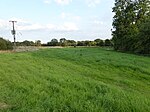
The Battle of Losecoat Field (also known as the Battle of Empingham) was fought on 12 March 1470, during the Wars of the Roses. Spellings of "Losecoat" vary, with "Losecote" and "Loose-coat" also seen. The battle secured the defeat of the poorly organised Welles Uprising against King Edward IV, but ultimately led to the defection of Richard Neville, 16th Earl of Warwick and the king's brother George, Duke of Clarence to the Lancastrian cause after they were forced to flee the country having been implicated in the rebellion.

Excerpt from the Wikipedia article Battle of Losecoat Field (License: CC BY-SA 3.0, Authors, Images).

Battle of Losecoat Field

Geographical coordinates (GPS) Address Nearby Places
placeShow on map

Wikipedia: Battle of Losecoat FieldContinue reading on Wikipedia

Geographical coordinates (GPS)

Latitude Longitude
N 52.686111111111 ° E -0.53611111111111 °
placeShow on map

Address

Mounts Lodge


PE9 4DF , Great Casterton
England, United Kingdom
mapOpen on Google Maps

York victory over Lancaster
Share experience

Nearby Places

Casterton College

Casterton College, Rutland (previously Casterton Business and Enterprise College (CBEC) and Casterton Community College) is one of three secondary schools in the county of Rutland, England. Located in the village of Great Casterton, the school provides education for eleven- to sixteen-year-olds, as well as a Childcare Centre for the under fives and an adult education programme. It opened as Great Casterton Secondary Modern School in 1939. The catchment area is the eastern part of Rutland including Cottesmore, Empingham and Ketton but the college attracts many of its students from Stamford, across the Lincolnshire boundary. Prior to academy conversion, the school had been rated as ‘outstanding’ in 2010. In December 2014, Ofsted rated the college as ‘requires improvement’ in all areas (teaching, behaviour, leadership and achievement). The then principal Victoria Crosher defended the fall in rating as partly due to changes in the "C" boundary at GCSE.With the withdrawal of the Tresham Institute from providing post-16 education in Rutland, CBEC in 2010 took over responsibility for Rutland College which was renamed Rutland County College. In 2015 it consulted on moving its entire sixth form from Oakham to its Casterton site. However, in March 2017, the college announced that the sixth form would be closing as not enough students showed interest to study there. Casterton College is joined with Ryhall Primary School and also with Casterton Childcare Centre. This means that the total group of education ranges from nursery to 16: Casterton Childcare Centre, Ryhall Primary School, Casterton College.

Pickworth, Rutland
Pickworth, Rutland

Pickworth is a civil parish and small village in the county of Rutland. The population of the civil parish at the 2001 census was 81. This remained less than 100 at the 2011 census and was included in the town of Stamford.The village's name means 'enclosure of Pica'.In the 13th century Pickworth was quite a substantial village, but by the end of the 14th century it was almost non-existent. It now comprises a small parish church, a disused Methodist chapel, a few large houses and a couple of rows of terraced and council houses. It lies in a landscape characterised by Rutland County Council as the clay woodlands of the Rutland Plateau (a Jurassic limestone plateau). At the southern boundary of the village is a crossroads leading to Great Casterton about three miles (5 km) to the south, the A1 road at Tickencote Warren to the west, Lincolnshire Gate and Castle Bytham to the north and an unmaintained track to Ryhall Heath to the east. All Saints' Church, Pickworth was built in 1821 and lies to the west of the village. The church is a Grade II listed building. Maps previously showed the spire of the demolished church under the name Mockbeggar to the west of the current village site. The remains of the old medieval village lie mainly to the west of the current village centre in an area referred to as Top Pickworth. The only visible remains, other than earthworks, is a stone arch.Just to the west of the village lie the remains of a lime kiln. In 1817 this was the workplace of local poet John Clare. About two miles (3 km) south-east is Walk Farm, formerly known as Walkherd Lodge, which was the home of Martha "Patty" Turner, who became John Clare's wife. Both the lime kiln and Walk Farm featured in a television documentary that was made about the poet in the late 1960s. About two miles (3 km) to the west of the village is the site of the Battle of Losecote Field in 1470. It has been claimed that the village was depopulated as a result of the fighting.