place

Tri-City Airport, San Bernardino

Airports in CaliforniaBuildings and structures in San Bernardino, CaliforniaPrivately owned airports
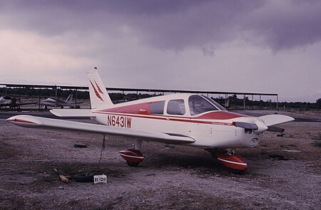
N6431W tricity dec 1966

Tri-City Airport was a small privately owned airport located in San Bernardino, California just north of Interstate 10 and east of Waterman Avenue. The Tri-City Corporate Center now occupies the land where it was located. It was owned by Pinky Brier and Joe Brier.

Excerpt from the Wikipedia article Tri-City Airport, San Bernardino (License: CC BY-SA 3.0, Authors, Images).

Tri-City Airport, San Bernardino
East Hospitality Lane, San Bernardino

Geographical coordinates (GPS) Address Nearby Places
placeShow on map

Wikipedia: Tri-City Airport, San BernardinoContinue reading on Wikipedia

Geographical coordinates (GPS)

Latitude Longitude
N 34.0671 ° E -117.2725 °
placeShow on map

Address

East Hospitality Lane 560
92354 San Bernardino
California, United States
mapOpen on Google Maps

N6431W tricity dec 1966
Share experience

Nearby Places

Hospitality Lane District, San Bernardino

The Hospitality Lane District is a business district in San Bernardino, California, located 2–3 miles (3-5 km) southeast of the city's downtown area along the street of the same name. It is adjacent to Interstate 10, and is only a few miles away from San Bernardino International Airport. The district primarily includes retail establishments, dining, and many of the city's hotels; it has been described as a "center of shopping and restaurant activity" in the San Bernardino Valley with some of the Inland Empire's "finest hotels, restaurants and office buildings". In addition, the area has attracted office development. Hospitality Lane is one of the most prosperous and developed areas in San Bernardino, a city which is otherwise economically troubled. However, the district has experienced increased crime as a result of its development, particularly due to its nightclubs. The district was built in a depressed area of San Bernardino after the city's Redevelopment Agency cleared the land and sold it to developers. In 2006, the last vacant property in Hospitality Lane was sold; at the time, the district had 16 restaurants. In 2011, the city proposed a center-lane exclusive high-speed bus line known as sbX in the Hospitality Lane area and is under construction as of 2013 with an expected launch date of January 2014. In 2008, the district experienced a small downturn as several businesses in the area closed; local economists stated that the downturn may have been caused by the economic recession.

2015 San Bernardino attack

On December 2, 2015, a terrorist attack, consisting of a mass shooting and an attempted bombing, occurred at the Inland Regional Center in San Bernardino, California. The perpetrators, Syed Rizwan Farook and Tashfeen Malik, a married couple living in the city of Redlands, targeted a San Bernardino County Department of Public Health training event and Christmas party of about 80 employees in a rented banquet room. Fourteen people were killed and 22 others were seriously injured. Farook was an American born citizen of Pakistani descent, who worked as a health department employee. Malik was a Pakistani-born green card holder. After the shooting, the couple fled in a rented Ford Expedition SUV. Four hours later, police pursued their vehicle and killed them in a shootout, which also left two officers injured. According to the FBI's investigation, the perpetrators were "homegrown violent extremists" inspired by foreign terrorist groups. They were not directed by such groups and were not part of any terrorist cell or network. FBI investigators have said that Farook and Malik had become radicalized over several years prior to the attack, consuming "poison on the internet" and expressing a commitment to jihadism and martyrdom in private messages to each other. Farook and Malik had traveled to Saudi Arabia in the years before the attack. The couple had amassed a large stockpile of weapons, ammunition, and bomb-making equipment in their home. Enrique Marquez Jr., a friend and former neighbor of Farook's, was investigated in connection with his purchase of the two rifles used in the attack. Marquez was arrested in December 2015, and later pleaded guilty to federal charges of providing material support for terrorism and making false statements in connection with the acquisition of a firearm. Marquez also admitted that, in 2011, he conspired with Farook to carry out shooting and bombing attacks, plans which were abandoned at the time. Three other people, including Farook's brother and sister-in-law, were arrested for immigration fraud in connection with a sham marriage between Marquez and Mariya Chernykh (the sister-in-law of Farook's brother). All three pleaded guilty. The attack was the deadliest mass shooting in the U.S. since the 2012 Sandy Hook Elementary School shooting, the deadliest terrorist attack to occur in the U.S. since the September 11 attacks and the deadliest mass shooting in California since the 1984 San Ysidro McDonald's massacre. It was surpassed by the Orlando nightclub shooting in June 2016.

Fort Benson
Fort Benson

Fort Benson was a Fort built in 1856 in present-day Colton in San Bernardino County, California. The Fort is named for its builder, Jerome Benson. The Fort was abandoned a year after it was built in 1857. Fort Benson was designated a California Historic Landmark (No.617) on September 11, 1957. Jerome Benson, in fear, built the Fort because of land disputes. The fort on his land claim, was made of earthworks and wood. The fort was defended by a brass cannon. The fort was used only one year as about half the Mormons around his land were told to return to Utah during the Mormon War, also call the Utah War. On December 27, 1858, the US Army arrived into San Bernardino. The US Army's Mojave Expedition leader was Colonel William Hoffman. He placed troops in San Bernardino and Cajon Pass to deal with Indians and the land problems. Fort Benson is gone and only a marker is at the spot of the fort. The Utah War (1857–1858) was an armed confrontation between Mormon settlers in the Utah Territory and the armed forces of the United States government. The confrontation lasted from May 1857 to July 1858. There were some casualties, mostly non-Mormon civilians. The war had no notable military battles. the Mormon War, or the Mormon Rebellion In 1857–1858, President James Buchanan sent U.S. forces to the Utah Territory in what became known as the Utah Expedition. The Mormons, fearful that the large U.S. military force had been sent to annihilate them and having faced persecution in other areas, made preparations for defense. Though bloodshed was to be avoided, and the U.S. government also hoped that its purpose might be attained without the loss of life, both sides prepared for war. The Mormons manufactured or repaired firearms, turned scythes into bayonets, and burnished and sharpened long-unused sabres.The Aiken massacre took place the following month. In October 1857, Mormons arrested six Californians traveling through Utah and charged them with being spies for the U.S. Army. They were released, but were later murdered and robbed of their stock and $25,000. Taking all incidents into account, MacKinnon estimates that approximately 150 people died as a direct result of the year-long Utah War, including the 120 migrants killed at Mountain Meadows. He points out that this was close to the number of people killed during the seven-year contemporaneous struggle in "Bleeding Kansas". In the end, negotiations between the United States and the Latter-day Saints resulted in a full pardon for the Mormons (except those involved in the Mountain Meadows murders), the transfer of Utah's governorship from church President Brigham Young to non-Mormon Alfred Cumming, and the peaceful entrance of the U.S. Army into Utah. Jedediah Smith camped the spot of the Fort in January 1827, on his first trip to California. He had departed San Diego after visiting Mexican Governor José María de Echeandía and was heading to the Central Valley after being ordered to leave.