place

Bondi Beach Cultural Landscape

Art museums and galleries in New South WalesBallrooms in AustraliaBathing in AustraliaBondi Beach, New South WalesCinemas in Sydney
Community buildings in New South WalesCultural landscapes of AustraliaEntertainment venues in New South WalesGardens in New South WalesNew South Wales State Heritage RegisterRestaurants in New South WalesRetail buildings in New South WalesSun tanningSwimming venues in AustraliaTheatres in SydneyUse Australian English from June 2018
Bondi Beach Pavilion Sep 2 2017

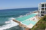
The Bondi Beach Cultural Landscape is a heritage-listed former Turkish baths, pavilion with dressing cubicles, dining rooms, sunbaking, shops and ballroom and now art gallery, pavilion, theatre and open air cinema located at Queen Elizabeth Drive, Bondi Beach, Sydney, Australia. The pavilion was designed by Robertson and Marks, with Leith C. McCredie the architect. The Bondi Surf Life Savers' Club, erected c. 1934, was designed by Ross & Rowe. The Bondi Pavilion was designed by John Howie & Sons. The cultural landscape includes the beach itself, Bondi Surf Pavilion, Bondi Park and Bondi Surf Life Saving Club and the North Bondi Surf Club. The landscape was added to the New South Wales State Heritage Register on 23 May 2008.

Excerpt from the Wikipedia article Bondi Beach Cultural Landscape (License: CC BY-SA 3.0, Authors, Images).

Bondi Beach Cultural Landscape
Hall Street, Sydney Bondi Beach

Geographical coordinates (GPS) Address Nearby Places
placeShow on map

Wikipedia: Bondi Beach Cultural LandscapeContinue reading on Wikipedia

Geographical coordinates (GPS)

Latitude Longitude
N -33.891 ° E 151.2767 °
placeShow on map

Address

Bondi Beach

Hall Street
2026 Sydney, Bondi Beach
New South Wales, Australia
mapOpen on Google Maps

Bondi Beach Pavilion Sep 2 2017
Share experience

Nearby Places

Mackenzies Bay
Mackenzies Bay

Mackenzies Bay is a small inlet in the coast between Bondi Beach and Tamarama Beach in the Eastern Suburbs of Sydney, New South Wales. It forms part of the shoreline boundary of the suburb of Tamarama. Most of the time, it is a rocky inlet but, at times, depending on prevailing conditions, a sandy beach—known informally as Mackenzies Bay Beach or Mackenzies—comes into existence. Mackenzies Bay is also a well-known surf break.In recent years, the beach existed at times during 2007, 2016, and 2019. Because it is not a permanent beach and is not patrolled, whenever it exists, the beach has become, de facto, a 'dog-friendly beach'.In the years up to 1947, the beach typically appeared around December and then disappeared around March, with the arrival of southerly gales. The beach then did not reappear until near the end of October 1951. The beach next reappeared in November 1953. In 1997, there was so much sand that, at low tide, it was almost possible to walk between Tamarama and South Bondi. In the years between 1997 and 2007, there was no beach. Unusually, in 2007, the beach arrived in May and disappeared in August. In September 2016 and December 2019, the beach followed its more typical pattern and appeared in time for the beginning of the Australian summer.The area was occupied by local Aborigines, before their dispossession in the years after Sydney was established in 1788. There is a rock engraving at Mackenzies Point depicting marine life. The age of the engraving is not known, but could be up to 2,000 years old.Mackenzies Bay and nearby Mackenzies Point are named after the Mackenzie family who, from the 1860s to approximately 1926, ran the Waverley Dairy on farmlands that stretched from near the corner of Bondi Road and Denham Street, east to the coast, and as far south as Gaerloch Avenue, Tamarama.