Chur Rhine Valley
Valleys of Graubünden

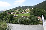
The Chur Rhine Valley (German: Churer Rheintal, also commonly known as the Bündner Rheintal) is that part of Nordbünden through which the Rhine flows from the confluence of Anterior and Posterior Rhine near Reichenau to the cantonal border near Maienfeld and Fläsch. The plain of Bonaduz and Rhäzüns also belongs to the Chur Rhine Valley and forms its southern end. The valley is part of the Alpine Rhine natural landscape.
Excerpt from the Wikipedia article Chur Rhine Valley (License: CC BY-SA 3.0, Authors, Images).Chur Rhine Valley
Maienfelderstrasse,
Geographical coordinates (GPS) Address Nearby Places Show on map
Geographical coordinates (GPS)
| Latitude | Longitude |
|---|---|
| N 46.977441 ° | E 9.557247 ° |
Address
Rohan-Schanze, neuzeitliche Schanze
Maienfelderstrasse
7302
Grisons, Switzerland
Open on Google Maps


