Vaalserberg
AachenBelgium–Germany border crossingsBelgium–Netherlands border crossingsBorder tripointsGerman-speaking Community of Belgium ... and 11 more
Germany–Netherlands border crossingsHighest points of countriesHills of South Limburg (Netherlands)KelmisMountains and hills of Liège ProvinceMountains and hills of North Rhine-WestphaliaMountains and hills of the Ardennes (Belgium)Mountains and hills of the EifelMountains and hills of the NetherlandsQuadripoints and higherVaals

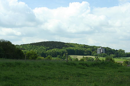
The Vaalserberg (Dutch pronunciation: [ˈvaːlsərˌbɛr(ə)x], Ripuarian: Volserberg [ˈvɔlsəʀˌbæʀ˦(ə)ç]) is a hill with a height of 322.4 metres (1,058 ft) above NAP and is the highest point in the European part of the Netherlands. The Vaalserberg is located in the province of Limburg, at the south-easternmost edge of the country, near the town of Vaals (after which it is named). Mount Scenery on the island of Saba, which is in the Caribbean part of the Netherlands, replaced Vaalserberg as the highest point in the Netherlands, following the dissolution of the Netherlands Antilles in 2010.
Excerpt from the Wikipedia article Vaalserberg (License: CC BY-SA 3.0, Authors, Images).Vaalserberg
Vaals
Geographical coordinates (GPS) Address Nearby Places Show on map
Geographical coordinates (GPS)
| Latitude | Longitude |
|---|---|
| N 50.754722222222 ° | E 6.0208333333333 ° |
Address
6291 BX Vaals
Limburg, Netherlands
Open on Google Maps


