Goat Canyon (Tijuana River Valley)

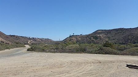
Goat Canyon (Spanish: Cañón de los Laureles) also known as Cañón de los Laureles, begins in Tijuana, Mexico, and ends in the United States just north of the Mexico–U.S. border. The canyon is formed by Goat Canyon Creek, which receives water and other runoff from areas south of the border. Most of the canyon and its watershed lies within Baja California.The canyon originated during the Quaternary period; it is bordered by Bunker Hill to its west and Spooner's Mesa to its east. Part of the canyon contains coastal salt marshland and supports numerous sensitive and endangered species.Human activity in and around the canyon pre-dates European colonization; it was part of a route used by the Portolá expedition to San Diego Bay and later formed part of the Missionary Road, which was abandoned in the late 19th century. Farms existed in and around Goat Canyon until the area came under the control of the federal government of the United States. Development south of the Tijuana-Ensenada scenic highway began in the late 20th century, causing sewage to flow northward, a problem that persisted into the 21st century.
Excerpt from the Wikipedia article Goat Canyon (Tijuana River Valley) (License: CC BY-SA 3.0, Authors, Images).Goat Canyon (Tijuana River Valley)
Border Patrol Road, San Diego
Geographical coordinates (GPS) Address Nearby Places Show on map
Geographical coordinates (GPS)
| Latitude | Longitude |
|---|---|
| N 32.5367 ° | E -117.0994 ° |
Address
Border Patrol Road
Border Patrol Road
91932 San Diego
California, United States
Open on Google Maps


