Dog Slaughter Falls
Landforms of Whitley County, KentuckyWaterfalls of KentuckyWhitley County, Kentucky, geography stubs
.jpg)
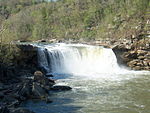
Dog Slaughter Falls is a 15 feet (4.6 m) to 20 feet (6.1 m) tall waterfall at the confluence of the Cumberland River and Dog Slaughter Creek, in the London Ranger District of the Daniel Boone National Forest in Whitley County, Kentucky. It is accessible via the Sheltowee Trace Trail, traveling downstream of Cumberland Falls, or via the Dog Slaughter Trail. The falls is rumored to be named for the drowning of unwanted pets, or the loss of hunting dogs to predatory wildlife.
Excerpt from the Wikipedia article Dog Slaughter Falls (License: CC BY-SA 3.0, Authors, Images).Dog Slaughter Falls
Dog Slaughter Trail #414,
Geographical coordinates (GPS) Address Nearby Places Show on map
 Continue reading on Wikipedia
 Geographical coordinates (GPS)
| Latitude | Longitude |
|---|---|
| N 36.858206 ° | E -84.311456 ° |
Address
Dog Slaughter Trail #414
Dog Slaughter Trail #414
Kentucky, United States
Open on Google Maps