place

River Deben

Ramsar sites in EnglandRivers of SuffolkSpecial Protection Areas in England
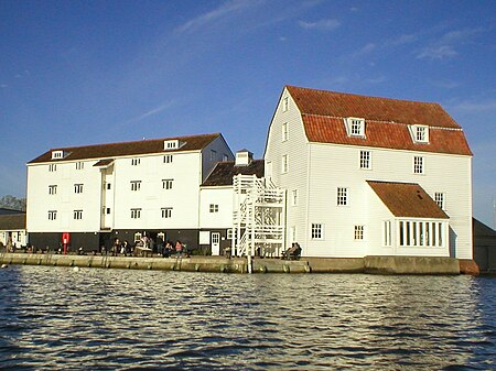
Woodbridge Tide Mill (1)

The River Deben is a river in Suffolk rising to the west of Debenham, though a second, higher source runs south from the parish of Bedingfield. The river passes through Woodbridge, turning into a tidal estuary before entering the North Sea at Felixstowe Ferry. The mouth of the estuary is crossed by a ferry connecting Felixstowe and Bawdsey.

Excerpt from the Wikipedia article River Deben (License: CC BY-SA 3.0, Authors, Images).

River Deben
Ferry Road, East Suffolk

Geographical coordinates (GPS) Address Nearby Places
placeShow on map

Wikipedia: River DebenContinue reading on Wikipedia

Geographical coordinates (GPS)

Latitude Longitude
N 51.9808 ° E 1.3927 °
placeShow on map

Address

Ferry Road
IP11 9RY East Suffolk
England, United Kingdom
mapOpen on Google Maps

Woodbridge Tide Mill (1)
Share experience

Nearby Places

Brackenbury Battery

Brackenbury Battery was a small coastal artillery fort located just north of Felixstowe, England,and initially known as Felixstowe Battery. It opened in October 1915 to provide fire northward from the Haven ports, replacing a battery of 10-inch guns that had previously covered this area. With their removal, only a single 10-inch gun in Landguard Fort could fire in that direction, and Brackenbury was built to address this problem. Brackenbury Battery was equipped with two of the newest 9.2-inch Mk IX guns, making it the most powerfully armed battery on the east coast at that time. The gun's carriages were set in concrete with shelters below, then surrounded by an earthen rampart and ditch. The guns were upgraded to Mk. X versions in 1929-1930. Trenches and strongpoints were added around the battery on the outbreak of World War II, and in 1941 two searchlights were placed on the beach to give the battery night fighting capability. The Battery had a role in the development of radar when, in July 1939, the guns were being test fired right as researchers at Bawdsey Manor, about 1 mile (1.6 km) to the north, were testing a new surface-scanning radar. The splashes of the shells produced strong returns on the radar displays, allowing the team to measure the distance and bearing of the fall of shot. This led to the development of Coast Artillery radar, and more generally the use of radar to guide naval gunfire. During WWII, the battery was manned by the 176 Battery of Suffolk Heavy Regiment Royal Artillery (Territorial Army), and later, 278 Battery of 515 Coast Regiment. It was put into care and maintenance in 1944, and formally stood down in 1952. The site was later redeveloped as a housing estate, and the area is now a greenspace. No sign of the battery remains.

Red Crag Formation
Red Crag Formation

The Red Crag Formation is a geological formation in England. It outcrops in south-eastern Suffolk and north-eastern Essex. The name derives from its iron-stained reddish colour and crag which is an East Anglian word for shells. It is part of the Crag Group, a series of notably marine strata which belong to a period when Britain was connected to continental Europe by the Weald–Artois Anticline, and the area in which the Crag Group was deposited was a tidally dominated marine bay. This bay would have been subjected to enlargement and contraction brought about by transgressions and regressions driven by the 40,000-year Milankovitch cycles. The sediment in the outcrops mainly consists of coarse-grained and shelly sands that were deposited in sand waves (megaripples) that migrated parallel to the shore in a south-westward direction. The most common fossils are bivalves and gastropods that were often worn by the abrasive environment. The most extensive exposure is found at Bawdsey Cliff, which is designated a Site of Special Scientific Interest (SSSI); here a width of around 2 kilometres (1.2 mi) of Crag is exposed. At the coastline by Walton-on-the-Naze, remains of megalodon were found.The Red Crag Formation at depth in eastern Suffolk clearly has one member, the Sizewell Member, a coarse shelly sand with thin beds of clay and silt. It was interpreted as having been deposited in large scale sand waves where the sea bed was deeper. The overlying Thorpeness Member, was provisionally assigned to the Red Crag based on its lithology but there is more evidence to suggest that it is part of the Norwich Crag Formation. It has been proposed that the Red Crag started in the late Pliocene and to have possibly extended up into the early Pleistocene, but there is disagreement on more precise dating. According to the British Geological Survey, the Red Crag sits within a segment of time from about 3.3 to 2.5 mya. It is considered that the Red Crag at Walton-on-the–Naze is the oldest and that it was deposited in only a few decades at some time between 2.9 and 2.6 mya. This has led to the UK stratigraphic stage name Waltonian, which is usually correlated with the final Pliocene Reuverian Stage in the Netherlands. There are difficulties in reconciling how the Red Crag equates with international chronological stages. In particular, the start and end dates are poorly defined due to the general paucity of age-diagnostic stratigraphic indicators and the fragmentary nature of the geology. It can also be difficult to separate the Red Crag from the overlying Norwich Crag Formation.