Caer Bach

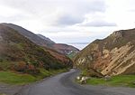
Caer Bach is a Welsh hillfort of indeterminate age, on a rounded hillock situated near the village of Rowen; in Conwy County, North Wales. Its name in English translates as 'Small Fort'; or alternatively 'Little Fortress'. It is situated on the Eastern slopes of Tal-y-Fan, an outlying peak of the Carneddau mountain range in northeast Snowdonia; at an altitude of approximately 413 metres (1,355 feet). Little information is known about the history of the fort, as to date, the site has undergone minimal investigation. The fort is classed as a scheduled ancient monument and is of national importance for its potential to enhance our knowledge of prehistoric settlement. It is said to retain significant archaeological potential, with a strong probability of the presence of associated archaeological features and deposits.
Excerpt from the Wikipedia article Caer Bach (License: CC BY-SA 3.0, Authors, Images).Caer Bach
Roman Road,
Geographical coordinates (GPS) Address Nearby Places Show on map
Geographical coordinates (GPS)
| Latitude | Longitude |
|---|---|
| N 53.23881469 ° | E -3.88313994 ° |
Address
Roman Road
LL32 8YW
Wales, United Kingdom
Open on Google Maps


