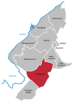
Westermarsch II
Aurich (district)

Westermarsch II was an independent municipality until the 1972 territorial reform in Lower Saxony and, as such, a member of the collective municipality (Samtgemeinde) of Leybucht in Lower Saxony. Today Westermarsch II is a village in the East Frisian borough of Norden with around 500 inhabitants (as at 12/2016). The village parish covers an area of 11.69 km². Curiously the main settlement of Westermarsch II is associated in public perception with the village of Norddeich, with which it has grown together. The boundary between the two runs down the middle of the road, Dörper Weg.
Excerpt from the Wikipedia article Westermarsch II (License: CC BY-SA 3.0, Authors, Images).Westermarsch II
Neudeicher Weg,
Geographical coordinates (GPS) Address Nearby Places Show on map
Geographical coordinates (GPS)
| Latitude | Longitude |
|---|---|
| N 53.593055555556 ° | E 7.1263888888889 ° |
Address
Neudeicher Weg
Neudeicher Weg
26506 , Westermarsch II (Westermarsch II)
Lower Saxony, Germany
Open on Google Maps


