place

St George's Cross subway station
1896 establishments in ScotlandGlasgow Subway stationsRailway stations in Great Britain opened in 1896Use British English from December 2017
17 11 15 Glasgow Subway RR70139

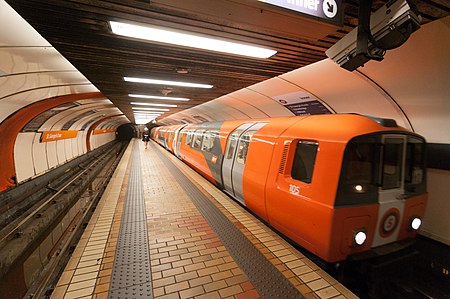
St George's Cross subway station is a Glasgow Subway station in Glasgow, Scotland which serves the areas of Woodside and Woodlands of the city. It is located at St George's Cross, previously an important road junction but realigned due to the construction of the M8 motorway and less heavily used by traffic since then. The station was opened in 1896 and comprehensively modernised in 1977–1980. It still retains its original island platform configuration, though surface buildings were rebuilt prior to the 1977-1980 modernisation scheme, as part of a new road project. This station recorded 580,000 boardings in the twelve months ending on 31 March 2005.St George's Cross is one of the stations mentioned in Cliff Hanley's song "The Glasgow Underground".

Excerpt from the Wikipedia article St George's Cross subway station (License: CC BY-SA 3.0, Authors, Images).

St George's Cross subway station
Cromwell Lane, Glasgow Woodside

Geographical coordinates (GPS) Address Nearby Places
placeShow on map

Wikipedia: St George's Cross subway stationContinue reading on Wikipedia

Geographical coordinates (GPS)

Latitude Longitude
N 55.871944444444 ° E -4.2697222222222 °
placeShow on map

Address

Cromwell Lane

Cromwell Lane
G4 9AD Glasgow, Woodside
Scotland, United Kingdom
mapOpen on Google Maps

17 11 15 Glasgow Subway RR70139
Share experience

Nearby Places

A82 road
A82 road

The A82 is a major road in Scotland that runs from Glasgow to Inverness via Fort William. It is one of the principal north-south routes in Scotland and is mostly a trunk road managed by Transport Scotland, who view it as an important link from the Central Belt to the Scottish Highlands and beyond. The road passes close to numerous landmarks, including Loch Lomond, Rannoch Moor, Glen Coe, the Ballachulish Bridge, Ben Nevis, the Commando Memorial, Loch Ness, and Urquhart Castle. The route is derived in several places from the military roads constructed through the Highlands by General George Wade and Major William Caulfeild in the 18th century, along with later roads constructed by Thomas Telford in the 19th. The modern route is based on that designed by Telford, but with a number of improvements primarily dating from the 1920s and 30s. These include a diversion across Rannoch Moor, and another around Loch Leven which was subsequently replaced by the Ballachulish Bridge. Several travel guides have praised individual parts of the road, such as the section from Tyndrum to Glencoe across Rannoch Moor, as providing memorable driving experiences. Tourists find the A82 a popular route because of its scenery, and it serves as a main artery for commercial and heavy goods traffic. Transport Scotland have publicly declared a commitment to improve congestion and safety along the road. Some sections are occasionally closed for maintenance, which has resulted in strong protest from the local community, and the road has been criticised for its poor accident record.

Charing Cross, Glasgow

Charing Cross is a major road junction in the Scottish city of Glasgow. It is situated north of the River Clyde at the intersection of Sauchiehall Street, St George's Road, Woodlands Road, North Street and Newton Street, as well as being at a major interchange of the M8 motorway. Taking its name originally from a block of tenements named Charing Cross Place built in the 1850s, which continue at the south-west corner with North Street, the junction of Sauchiehall Street was formed as part of the original development of Blythswood Hill including Blythswood Square, St George's Road and North Street becoming known as Charing Cross, linking the city centre and the new West End, commencing at Woodlands and Sandyford. Much of its architecture was destroyed when the motorway was built through it in the late 1960s, notably the Grand Hotel at its heart. It still marks the boundary between the City Centre and the West End of the city. There are ornate red sandstone tenement blocks dating from the late Victorian period at two corners of the junction, at the north-west (St George's Mansions, Frank Burnet) and south-east (Charing Cross Mansions, John James Burnet), while nearby landmarks include the Mitchell Library. In 2019, Glasgow City Council put forward plans to cover over more of the motorway (which is in a cutting through the area) with a parkland area to better connect the areas on each side.Charing Cross was also part of the so-called Square Mile of Murder, the location of a series of sensational murders which scandalised Victorian society.Charing Cross railway station is a short distance to the south; the nearest Glasgow Subway station is St George's Cross, located at the junction of the same name to the north of Charing Cross, also much diminished in its importance by the installation of the M8. Nearby is an abstract concrete relief mural by Keith McCarter, made circa 1972.