place

Pedra da Gávea

Geography of Rio de Janeiro (city)HyperdiffusionismLandforms of Rio de Janeiro (state)Mountains of BrazilNational heritage sites of Rio de Janeiro (state)
Pre-Columbian trans-oceanic contactPseudoarchaeology
Nebulosa Pedra da Gávea

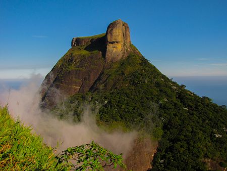
Pedra da Gávea is a monolithic mountain in Tijuca Forest, Rio de Janeiro, Brazil. Composed of granite and gneiss, its elevation is 844 metres (2,769 ft), making it one of the highest mountains in the world that ends directly in the ocean. Trails on the mountain were opened up by the local farming population in the early 1800s; today, the site is under the administration of the Tijuca National Park.The mountain's name translates as Rock of the Topsail, and was given to it during the expedition of Captain Gaspar de Lemos, begun in 1501, and in which the Rio de Janeiro bay (today Guanabara Bay, but after which the city was named) also received its name. The mountain, one of the first in Brazil to be named in Portuguese, was named by the expedition's sailors, who compared its silhouette to that of the shape of a topsail of a carrack upon sighting it on January 1, 1502. That name in turn came to be given to the Gávea area of the city of Rio de Janeiro.Differential weathering on one side of the rock has created what is described as a stylized human face. Markings on another face of the rock have been described as an inscription. Geologists and scientists are nearly in agreement that the "inscription" is the result of erosion and that the "face" is a product of pareidolia. Furthermore, the consensus of archaeologists and scholars in Brazil is that the mountain should not be viewed as an archaeological site.

Excerpt from the Wikipedia article Pedra da Gávea (License: CC BY-SA 3.0, Authors, Images).

Pedra da Gávea
Acesso a vias de escalada, Rio de Janeiro São Conrado

Geographical coordinates (GPS) Address Nearby Places
placeShow on map

Wikipedia: Pedra da GáveaContinue reading on Wikipedia

Geographical coordinates (GPS)

Latitude Longitude
N -22.996521 ° E -43.281927 °
placeShow on map

Address

Acesso a vias de escalada

Acesso a vias de escalada
22610-390 Rio de Janeiro, São Conrado
Rio de Janeiro, Brazil
mapOpen on Google Maps

Nebulosa Pedra da Gávea
Share experience

Nearby Places

São Conrado
São Conrado

São Conrado (Portuguese: /sɐ̃w̃ kõˈʁadu/) is a neighborhood in the South Zone of the city of Rio de Janeiro, Brazil. It is nestled in between the neighborhoods of Barra da Tijuca to the southwest and Leblon to the northeast. The neighborhood takes its name from a small church, Igreja de São Conrado (Church of São Conrado), which was constructed early in the 20th century by Conrado Jacob Niemeyer (1831-1905). São Conrado, which ranks as one of the areas with the highest Human Development Index in Brazil, presents a stark contrast to Rocinha on its border, which is one of the largest and poorest favelas in Brazil. São Conrado is famous for its hang gliding (popular with locals and tourists alike), Fashion Mall which houses over 150 stores carrying national and international designers, and golf course. The neighborhood, or bairro, is made up of sophisticated residential buildings, night clubs, and elegant restaurants. The famous Morro Dois Irmãos, or Two Brothers Mountain, featured in movies, television shows, and postcards from the city, separates the neighborhood from the rest of the South Zone. It is also noted for the mansions on the foot of the Pedra da Gávea, the largest seaside granite rock on Earth, which separates São Conrado from the West Zone. The House at Canoas (Casa das Canoas), the private home of Oscar Niemeyer (1907-2012), is located on Estrada das Canoas and is considered a masterpiece of Mid-century modern residential architecture.São Conrado has been the most expensive and sought-after address in Rio, with celebrities such as Xuxa and even the mayor calling the area home. Real estate in the neighborhood is some of the priciest in South America.