place

Fowler River

New Hampshire river stubsRivers of Grafton County, New HampshireRivers of New HampshireTributaries of the Merrimack River
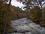
FowlerRiverNH Oct2012

The Fowler River is a 6.1-mile-long (9.8 km) river located in central New Hampshire in the United States. It is an inflow to Newfound Lake, part of the Pemigewasset and Merrimack River watersheds. Below Bog Brook, the Fowler River is subject to the New Hampshire Comprehensive Shoreland Protection Act. The primary tributary of the river is Clark Brook, which rises south of Mount Cardigan in the town of Alexandria and drops over Welton Falls. Chesley Brook joins from the north, at which point the stream valley widens and begins to support small agricultural operations. The brook's name changes to "Fowler River" when Brock Brook joins from the right at the first crossing of Fowler River Road. The river flows southeast to a junction with Bog Brook, where it turns north and flows one mile to Newfound Lake.

Excerpt from the Wikipedia article Fowler River (License: CC BY-SA 3.0, Authors, Images).

Fowler River
Bayberry Lane,

Geographical coordinates (GPS) Address Nearby Places
placeShow on map

Wikipedia: Fowler RiverContinue reading on Wikipedia

Geographical coordinates (GPS)

Latitude Longitude
N 43.639166666667 ° E -71.7725 °
placeShow on map

Address

Bayberry Lane

Bayberry Lane
03222
New Hampshire, United States
mapOpen on Google Maps

FowlerRiverNH Oct2012
Share experience

Nearby Places

Central Square Historic District (Bristol, New Hampshire)

The Central Square Historic District of Bristol, New Hampshire, encompasses the central commercial district of the town. The square is a four-sided space near the junction of six roadways in the center of Bristol, just north of the Newfound River and west of the Pemigewasset River. The district includes all of the buildings that are arrayed around the square, as well as one contemporary commercial building located just south of the Newfound River on South Main Street. The district was listed on the National Register of Historic Places in 1983.The center of Bristol began to take shape in the 1760s with the arrival of the first non-Native settlers. A road was cut along the Pemigewasset River, which crossed the Newfound River near where South Main Street does today. A mill was built a little way to the east. By the 1790s a small town center had emerged, including two tavern buildings that still stand. A new road (now North Main Street) to Newfound Lake in 1805 further enhanced the area's importance as a transportation junction, shortly followed by what is now Pleasant Street in 1808. How the square itself formed is uncertain, since there are no formal town documents discussing the matter.The center grew in the 19th century with the arrival of industrial mills and the railroad. Most of the municipal functions were located away from the square, which developed as a commercial business district. Early surviving instances of wood frame commercial construction include in the 1841 Bean-Tukey Block and the 1848 Cass Block. The west side of the square was subjected to destructive fires in 1861 and 1871, resulting in the construction of Victorian brick blocks on that side of the square. The square's basic structures today are, with only few exceptions, what they were in the late 19th century.