Night action of 1/2 December 1917

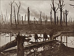
The Night action of 1/2 December 1917 during the First World War, was a local operation on the Western Front, in Belgium at the Ypres Salient. The action was a British Fourth Army (re-named from the Second Army on 8 November) attack on the German 4th Army. The Third Battle of Ypres (31 July – 10 November) proper had ended officially on 20 November but the attack was intended to capture the heads of valleys leading eastwards from the ridge, to gain observation over German positions. On 18 November the VIII Corps on the right and II Corps on the left (northern) side of the Passchendaele Salient, took over from the Canadian Corps. The area was subjected to constant German artillery bombardment and its vulnerability to attack led to a suggestion by Brigadier Cecil Aspinall that the British should either retire to the west side of the Gheluvelt Plateau or advance to broaden the salient towards Westroosebeke (now Westrozebeke). Expanding the salient would make the troops in it less vulnerable to German artillery-fire and provide a better jumping off line for a resumption of the offensive in the spring of 1918. The British attacked towards Westroozebeke on the night of 1/2 December, dispensing with a preliminary bombardment s a ruse, the artillery remaining silent until eight minutes after the infantry advanced. The ploy failed because the noise of the British assembly and the difficulty of moving across muddy and waterlogged ground had alerted the Germans. In the moonlight, the British troops were visible when they were still 200 yd (180 m) short of the German defences. Some ground was captured and about 150 prisoners were taken but the attack on the redoubts failed and observation over the heads of the valleys on the east and north sides of the ridge, was not gained.
Excerpt from the Wikipedia article Night action of 1/2 December 1917 (License: CC BY-SA 3.0, Authors, Images).Night action of 1/2 December 1917
Grenadiersstraat,
Geographical coordinates (GPS) Address Nearby Places Show on map
Geographical coordinates (GPS)
| Latitude | Longitude |
|---|---|
| N 50.9 ° | E 3.0166666666667 ° |
Address
Grenadiersstraat 18
8980
West Flanders, Belgium
Open on Google Maps


