place

Horseferry Road drill hall

Buildings and structures in the City of WestminsterDrill halls in London
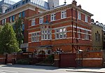
Territorial Army building, Westminster geograph.org.uk 2326136

The Horseferry Road drill hall was a military installation at 95 Horseferry Road, London.

Excerpt from the Wikipedia article Horseferry Road drill hall (License: CC BY-SA 3.0, Authors, Images).

Horseferry Road drill hall
Horseferry Road, London Millbank

Geographical coordinates (GPS) Address Nearby Places
placeShow on map

Wikipedia: Horseferry Road drill hallContinue reading on Wikipedia

Geographical coordinates (GPS)

Latitude Longitude
N 51.49527 ° E -0.13324 °
placeShow on map

Address

London Scottish House

Horseferry Road 95
SW1P 2DX London, Millbank
England, United Kingdom
mapOpen on Google Maps

Territorial Army building, Westminster geograph.org.uk 2326136
Share experience

Nearby Places

Lawrence Hall, London

Lawrence Hall in Greycoat Street, Westminster was the newer of the two Royal Horticultural Halls owned by R.H.S. Enterprises Limited, which is part of the Royal Horticultural Society charity in central London. The other is Lindley Hall in Elverton Street; both are close to the RHS' headquarters in Vincent Square. The site of Lawrence Hall incorporates a self-contained purpose-built conference centre above the main hall. The building's name relates to Trevor Lawrence, president of the Royal Horticultural Society from 1885 to 1913 who was chiefly responsible for moving the Society from its expensive Kensington site to a more practical home in Westminster in 1904. Lawrence Hall has vaulted ceilings and Art Deco interior features. It was awarded a gold medal by the Royal Institute of British Architects for its dramatic architecture. It was constructed between 1925 and 1928 and was designed by the partnership of Easton and Robertson. The tall parabolic arches which begin as square piers are credited to Easton, derived from the reinforced concrete work of Hennebique and Freyssinet. It has been listed Grade II* on the National Heritage List for England since 1983.Lawrence Hall and the conference centre underwent a £1.2 million renovation in 2006. Although built as an exhibition hall, Lawrence Hall was increasingly used for product launches and conferences. In December 2011 the RHS announced that it had leased the hall for 999 years to Westminster School for £18 million, the terms allowing the hall to continue to be used for four RHS flower shows each year. Westminster School has converted the building for use as a Sports Centre. It was used as a filming location for Pink Floyd - The Wall, Indiana Jones and the Last Crusade, Richard III, The Saint, Killing Eve, and Children of Men.

Westminster Pit
Westminster Pit

The Westminster Pit was a well-known blood sport arena in nineteenth-century London, England. It reached a zenith of popularity between 1820 and 1830, and hosted such spectacles as dog-fighting, cock-fighting, bear-baiting, badger-baiting, monkey-baiting, and rat-baiting. A legal enterprise at the time, the Westminster Pit openly declared its activities, ushering notoriety on the district in which it existed. The Westminster Pit was located on Duck Lane, Orchard Street (since renamed St. Matthew's Street), and its dimensions were approximately 20 feet (6.1 m) by 18 feet (5.5 m). The gallery was 3 feet (0.91 m) above the arena and was capable of containing 200 people – or, by report of William Pitt Lennox, "perhaps a greater number of less refractory persons, for the common run of spectators were so obstreperous and so agitated by various emotions, according to the amount of bets depending, and the various turns of the conflict, that a decent orderly person would feel himself much incommoded by a considerably less number."Prior to the beginning of matches, the stakes would be formalised and the dogs weighed. It was common in the Westminster Pit (and other venues like it) for cheating to occur, often by way of covering a dog with substances – such as acid or pepper – that would deter his opponent from biting him. For this reason, it was compulsory that all combatants be washed in water or milk, and a participant was permitted to lick his opponent's dog as a precaution.Perhaps the most famous dog to perform in the Westminster Pit was a bull and terrier named "Billy", whose fame was his rat-baiting ability. The October 1822 edition of The Sporting Magazine describes his feat of killing 100 rats in six minutes and twenty-five seconds: almost six minutes faster than what was wagered. Billy's best time ever is recorded as five minutes, or slightly over "by a very few seconds". The name of Billy's owner is not consistently documented: some sources refer to a Charles Dew, some to Charley Westropp, and others to Charley Aistrop. Pierce Egan gives Billy's date of death as 23 February 1829. Later commentators have questioned the legitimacy of Billy's success; in particular, James Rodwell, in his 1858 The rat: its history & destructive character: With numerous anecdotes, stated: "let it be borne in mind, and I assert it on the testimony of living witnesses, that numbers of the rats were dead before the dog commenced, and that the whole had been poisoned with nux-vomica before being put into the pit . . . and when he did commence, several were thrown out as dead that were able to crawl away".In 1830, an indictment was lodged against the Westminster Pit by the Society for the Prevention of Cruelty to Animals. The Society charged the proprietor, John King, with a nuisance, while noting that it was "indebted to corporal Denny, of No. 17, Queen Square, Westminster, and to James Yewen, of No. 6, Horseferry Road, Westminster . . . for obtaining a sufficient number of witnesses, residing on the spot, to prove the case as a nuisance." King was convicted, and, according to The Cottager's monthly visitor, "the prosecution completely suppressed that notorious sink of cruelty and vice".

Horseferry Road
Horseferry Road

Horseferry Road is a street in the City of Westminster in central London running between Millbank and Greycoat Place. It is perhaps best known as the site of City of Westminster Magistrates' Court (which until 2006 was called Horseferry Road Magistrates' Court). The ubiquity of the Magistrates' Court in newspaper crime reports means that the road name has wide recognition in the UK. Other notable institutions which are or have been located on Horseferry Road include Broadwood and Sons, the Gas Light and Coke Company, British Standards Institution, the Royal College of Veterinary Surgeons, the Burberry Group, the Environment Agency headquarters in Horseferry House, the National Probation Service, the Department for Transport and Channel 4. The Marsham Street Home Office building backs on to this road. The road is designated part of the B323 road, along with Greycoat Place, Artillery Row and Buckingham Gate.The road takes its name from the ferry which existed on the site of what is now Lambeth Bridge. Owned by the Archbishop of Canterbury, the ferry was an important crossing over the Thames, from Westminster Palace to Lambeth Palace. The earliest known reference to the ferry dates to 1513, but there may have been a ford near the site in Roman times. The ferry pier was the starting point for the flight of King James II from England in 1689. In 1736, Princess Augusta, who became the mother of George III, crossed the Thames via the horse ferry on the way to her wedding. In 1734, plans were drawn up for a bridge to replace the ferry. An Act of Parliament was passed in 1736, and the money was raised by lottery and grants. Parliament changed the plans for the position of the bridge, and Westminster Bridge was finished first, resulting in the gradual decline of the ferry. It was eventually replaced on 10 November 1862, when the first Lambeth Bridge was opened. It quickly deteriorated, and was replaced in 1932. Horseferry Road has been the site of numerous Government buildings including Horseferry House, which was the location of No. 5 (London) Regional Fire Control Centre during World War II, and the headquarters of 26th Middlesex (Cyclist) Volunteer Rifle Corps. The building was most recently used by the Home Office to house Prison and Probation head office staff, and is as of 2007 being converted into residential flats. The regimental headquarters and museum of the London Scottish Regiment is at no. 95, this was where the inquiry into the sinking of RMS Titanic took place in 1912. During World War I the Australian Imperial Force's Administrative Headquarters was located on Horseferry Road. They rented the buildings from Westminster Training College throughout the war while the college was evacuated to Richmond. Established by the Methodist Church in 1851, Westminster College occupied the site until it relocated to Oxford in 1959. Today their Oxford site is the Harcourt Hill Campus of Oxford Brookes University, but the archives and art collections of Westminster College can still be viewed on the site. Their site on Horseferry Road meanwhile is now the location for the Channel 4 Headquarters, which were built there in 1994. Phyllis Pearsall conceived and created the London A to Z map while living in a bedsit in Horseferry Road.There is another Horseferry Road in Limehouse, London E14 parallel to Narrow Street, and another off Creek Road in Greenwich.