place

Godrevy Lighthouse

Grade II listed buildings in CornwallGrade II listed lighthousesLighthouses completed in 1859Lighthouses in CornwallUse British English from March 2017
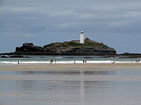
Godrevy Island and Lighthouse (10764130205)

Godrevy Lighthouse was built in 1858–1859 on Godrevy Island in St Ives Bay, Cornwall. Standing approximately 300 metres (980 ft) off Godrevy Head, it marks the Stones reef, which has been a hazard to shipping for centuries.

Excerpt from the Wikipedia article Godrevy Lighthouse (License: CC BY-SA 3.0, Authors, Images).

Godrevy Lighthouse
Churchtown Road,

Geographical coordinates (GPS) Address Website External links Nearby Places
placeShow on map

Wikipedia: Godrevy LighthouseContinue reading on Wikipedia

Geographical coordinates (GPS)

Latitude Longitude
N 50.2425 ° E -5.4002777777778 °
placeShow on map

Address

Godrevy Lighthouse

Churchtown Road
TR27 5EE
England, United Kingdom
mapOpen on Google Maps

Website
trinityhouse.co.uk

linkVisit website

linkWikiData (Q15221791)
linkOpenStreetMap (845047907)

Godrevy Island and Lighthouse (10764130205)
Share experience

Nearby Places

St Ives Bay
St Ives Bay

St Ives Bay (Cornish: Roda Ia, meaning "Ia's anchorage") is a bay on the Atlantic coast of north-west Cornwall, England, United Kingdom. It is in the form of a shallow crescent, some 4 miles or 6 km across, between St Ives in the west and Godrevy Head in the east. At the most southerly point of St Ives Bay, the River Hayle flows into the sea through sand dunes and across the beach. Behind the dunes, the river forms a broad tidal estuary which includes an area of salt marsh and a largely disused port (see article on the industrial history of Hayle). The estuary is a popular place for birdwatching and the Royal Society for the Protection of Birds maintains a reserve there. The eastern coast of the bay is a three-mile (5 km) unbroken sandy beach backed by a substantial system of coastal dunes known as The Towans which stretches from Porth Kidney Sands in the west to Godrevy Head in the east. This stretch of beach is popular for surfing, particularly in the Gwithian area. The western side of the bay is on higher ground and is more densely inhabited with substantial settlements at Lelant, Carbis Bay and St Ives. The western coast of the bay is rockier with several small beaches separated by headlands. The Stones reef lies about one mile north-west of Godrevy Head and presents a hazard to navigation - the lighthouse on Godrevy Island warns mariners of the danger. Inshore hazards include the strong tidal stream around Godrevy Island and the tidal current at the mouth of the River Hayle.