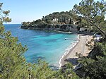
Cap Ferrat
French RivieraHeadlands of FranceLandforms of Provence-Alpes-Côte d'AzurPages with French IPATourist attractions in Alpes-Maritimes ... and 1 more
Villages in Provence-Alpes-Côte d'Azur

Cap Ferrat (pronounced [kap fɛʁa]; English: Cape Ferrat) is a cape situated in the Alpes-Maritimes department in Southeastern France. It is located in the commune of Saint-Jean-Cap-Ferrat. Hospitius lived there as a recluse during the 6th century. Thus, the cape is sometimes called Cap-Saint-Hospice or Cap-Saint-Sospis. Once the domain of King Leopold II of Belgium, Cap Ferrat is now graced with a number of magnificent villas, most notably the Villa Ephrussi de Rothschild.
Excerpt from the Wikipedia article Cap Ferrat (License: CC BY-SA 3.0, Authors, Images).Cap Ferrat
Boulevard du Général de Gaulle, Nice
Geographical coordinates (GPS) Address Website Nearby Places Show on map
Geographical coordinates (GPS)
| Latitude | Longitude |
|---|---|
| N 43.6875 ° | E 7.3291666666667 ° |
Address
Jeunesse sportive Saint-Jean / Beaulieu
Boulevard du Général de Gaulle
06230 Nice
Provence-Alpes-Côte d'Azur, France
Open on Google Maps


