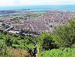
Sandfields, Port Talbot
Districts of Neath Port TalbotGlamorgan electoral wardsPort TalbotSwansea Bay
Sandfields (Welsh: Traethmelyn) is a mainly residential district of Port Talbot, Wales. The area is located in South Wales on a narrow coastal plain between Mynydd Dinas and the sea. The M4 motorway, A48 trunk road and South Wales Main Line run nearby. The area includes a council estate, industrial areas and a seaside resort at Aberavon Beach.
Excerpt from the Wikipedia article Sandfields, Port Talbot (License: CC BY-SA 3.0, Authors).Sandfields, Port Talbot
St. David's Road,
Geographical coordinates (GPS) Address Nearby Places Show on map
Geographical coordinates (GPS)
| Latitude | Longitude |
|---|---|
| N 51.593611111111 ° | E -3.8030555555556 ° |
Address
St. David's Road
St. David's Road
SA12 6PE , Sandfields East
Wales, United Kingdom
Open on Google Maps


