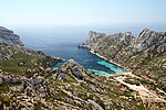
Massif des Calanques
9th arrondissement of MarseilleBouches-du-Rhône geography stubsGeography of MarseilleLandforms of Bouches-du-RhôneLandforms of Provence-Alpes-Côte d'Azur ... and 4 more
Massif des CalanquesNortheastern Spain and Southern France Mediterranean forestsRock formations of FranceTourist attractions in Bouches-du-Rhône

The Massif des Calanques (French pronunciation: [masif de kalɑ̃k]) is a wild and rugged terrain stretching from the ninth arrondissement of Marseille to the east towards Cassis, spanning 20 km in length and 4 km in width along the coast. Its highest peak is Mont Puget at 565m. The area has been protected by a national park since 2012.
Excerpt from the Wikipedia article Massif des Calanques (License: CC BY-SA 3.0, Authors, Images).Massif des Calanques
Chemin de Morgiou, Marseille 9th Arrondissement
Geographical coordinates (GPS) Address Nearby Places Show on map
Geographical coordinates (GPS)
| Latitude | Longitude |
|---|---|
| N 43.216666666667 ° | E 5.4333333333333 ° |
Address
Chemin de Morgiou
Chemin de Morgiou
13009 Marseille, 9th Arrondissement
Provence-Alpes-Côte d'Azur, France
Open on Google Maps


