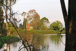
place

Lake Herrera

Altiplano CundiboyacenseAndean preceramicArchaeological sites of the Altiplano CundiboyacenseFormer populated places in ColombiaGeography of Cundinamarca Department
Lakes of ColombiaTourist attractions in Cundinamarca DepartmentTourist attractions near Bogotá

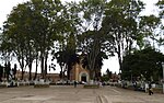
Lake Herrera is a small lake located at 5 kilometres (3.1 mi) from the urban centre of Mosquera and about 20 kilometres (12 mi) west of the capital Bogotá in Cundinamarca, Colombia. The Andean lake has made its name in the Herrera Period, the period in the history of central Colombia before the Muisca Period, after archaeologist Sylvia Broadbent excavated ceramics around Lake Herrera in 1971.

Excerpt from the Wikipedia article Lake Herrera (License: CC BY-SA 3.0, Authors).

Geographical coordinates (GPS)

Latitude Longitude
N 4.6905555555556 ° E -74.274722222222 °
placeShow on map

Address


250047
Colombia
mapOpen on Google Maps

Share experience

Nearby Places

Bacatá
Bacatá

Bacatá (Chibcha: Muyquytá or Muequetá) is the name given to the main settlement of the Muisca Confederation on the Bogotá savanna. It mostly refers to an area, rather than an individual village, although the name is also found in texts referring to the modern settlement of Funza, in the centre of the savanna. Bacatá was the main seat of the zipa, the ruler of the Bogotá savanna and adjacent areas. The name of the Colombian capital, Bogotá, is derived from Bacatá, but founded as Santafe de Bogotá in the western foothills of the Eastern Hills in a different location than the original settlement Bacatá, west of the Bogotá River, eventually named after Bacatá as well. The word is a combination of the Chibcha words bac, ca and tá, and means "(enclosure) outside the farmfields", referring to the rich agricultural lands of the Sabana Formation on the Bogotá savanna. Bacatá was submitted to the Spanish Empire by the conquistadors led by Gonzalo Jiménez de Quesada on April 20, 1537. Santafe de Bogotá, the capital of the New Kingdom of Granada, was formally founded on August 6, 1538. The last zipa of an independent Bacatá was Tisquesusa, who died after being stabbed by a Spanish soldier. His brother, Sagipa, succeeded him and served as last zipa under Spanish rule. The name Bacatá is maintained in the highest skyscraper of Colombia, BD Bacatá, and in the important fossil find in the Bogotá Formation; Etayoa bacatensis.

Aguazuque

Aguazuque is a pre-Columbian archaeological site located in the western part of the municipality Soacha, close to the municipalities Mosquera and San Antonio del Tequendama in Cundinamarca, Colombia. It exists of evidences of human settlement of hunter-gatherers and in the ultimate phase primitive farmers. The site is situated on the Bogotá savanna, the relatively flat highland of the Altiplano Cundiboyacense close to the present-day course of the Bogotá River at an altitude of 2,600 metres (8,500 ft) above sea level. Aguazuque is just north of another Andean preceramic archaeological site; the rock shelter Tequendama and a few kilometres south of Lake Herrera. The artefacts found mostly belong to the preceramic period, and have been dated to 5025 to 2725 BP (3000 to 700 BCE). Thus, the younger finds also pertain to the later ceramic Herrera Period. There were some difficulties in dating of the uppermost layer due to modern agricultural activity in the area; the sediments of the shallower parts were disturbed. At Aguazuque multiple palaeoanthropological finds have been made; stone and bone tools, remains of fireplaces and a multitude of pre-Columbian foods, primitive circular housing, various burial sites of individual and group interments and in the youngest dated layers, evidences of ceramics. The site represents a transition from a hunter-gatherer culture towards the earliest evidence of agriculture. A phase of settlement is attested where the people moved away from the caves and rock shelters and started inhabiting open area grounds. Investigation of Aguazuque has been conducted since 1986, mainly by archaeologist Gonzalo Correal Urrego who published the results of his studies in the book Aguazuque - evidencias de cazadores, recolectores y plantadores en la altiplanicie de la Cordillera Oriental in 1990.