place

Diseworth

Charities based in LeicestershireFormer civil parishes in LeicestershireHistoric preservationNorth West Leicestershire DistrictUse British English from July 2015
Villages in Leicestershire
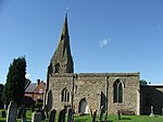
Diseworth Village geograph.org.uk 1343922

Diseworth is a village and former civil parish, now in the parish of Long Whatton and Diseworth, in the North West Leicestershire district, in the English county of Leicestershire. It is south of East Midlands Airport and off Junction 23A of the M1 motorway. A village of some 670 residents, it is located 14 km to the north-west of Loughborough and 2.5 km to the south-east of Castle Donington. The settlement is in the civil parish of Long Whatton and Diseworth, and lies within an undulating agricultural landscape and occupies a shallow valley created by the Diseworth Brook as it flows eastwards before becoming Long Whatton Brook and proceeding to its confluence with the River Soar. The four principal streets of the village - Grimes Gate, Hall Gate, Clements Gate and Lady Gate - meet at The Cross; a staggered crossroads close to the Church of St Michael's and All Angels. Page Lane runs parallel to Lady Gate. The Green running along the southern edge of the settlement gives access into Hall Gate - via The Bowley -and into Lady Gate. Diseworth Brook flows to the south of Hall Gate and is joined by tributaries to the east of Shakespear Close and near Town End. The famous astrologer and occultist, William Lilly was born in Diseworth on 1 May 1602.

Excerpt from the Wikipedia article Diseworth (License: CC BY-SA 3.0, Authors, Images).

Diseworth
The Woodcroft, Derby Long Whatton and Diseworth

Geographical coordinates (GPS) Address Nearby Places
placeShow on map

Wikipedia: DiseworthContinue reading on Wikipedia

Geographical coordinates (GPS)

Latitude Longitude
N 52.81527 ° E -1.33377 °
placeShow on map

Address

The Woodcroft 13
DE74 2QT Derby, Long Whatton and Diseworth
England, United Kingdom
mapOpen on Google Maps

Diseworth Village geograph.org.uk 1343922
Share experience

Nearby Places

Donington Park motorway services

Donington Park is a motorway service station owned by Moto, near Kegworth village in the English East Midlands. It is accessed from the M1 motorway by junctions 23a (from the south) and 24 (from the north), and is part of the complex of junctions involving the A42, A453, A50 and A6 roads. The service station is adjacent to East Midlands Airport and the East Midlands Gateway freight terminal, and is some 3 miles (4.8 km) from the Donington Park motorsport circuit, from which it takes its name.The service area comprises a main building, with car parking to the north, a separate refuelling station to the east and a conservation area and lake to the south. The main building has a central three-story high atrium containing a food court, with flanking three-story wings to west and east containing retail outlets and other facilities on the ground floor, and the rooms of a Travelodge hotel in the upper floors. The main entrance to the building is from the car park to the north, whilst at the south end is an outdoor terrace overlooking the lake.From a local government perspective, the service station is in the civil parish of Long Whatton and Diseworth, the district of North West Leicestershire and the county of Leicestershire.Donington Park motorway services opened on 8 July 1999, being originally owned by Granada, which became Moto in 2001. It was one of the first to offer a whole set of non-food shops, similar to an airport, which now has been adopted as standard. The neighbouring airport has far fewer landside facilities for those awaiting arrivals (before check-in).