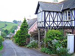
Kingskerswell

Kingskerswell (formerly Kings Carswell, or Kings Kerswell) is a village and civil parish within Teignbridge local government district in the south of Devon, England. The village grew up where an ancient track took the narrowest point across a marshy valley and it is of ancient foundation, being mentioned in the Domesday Book. It has a church dating back to the 14th century and the ruins of a manor house of similar date. The coming of the railway in the 1840s had a large effect on the village, starting its conversion into a commuter town. The village is a major part of the electoral ward called Kerswell-with-Combe. This ward had a population of 5,679 at the 2011 census.It was situated on a busy main road, part of the A380, between Torquay and Newton Abbot until the opening of the South Devon Highway in December 2015. There had been proposals to reroute this road to relieve the traffic bottleneck since 1951.
Excerpt from the Wikipedia article Kingskerswell (License: CC BY-SA 3.0, Authors, Images).Kingskerswell
Fluder Rise, Teignbridge Kingskerswell
Geographical coordinates (GPS) Address Nearby Places Show on map
Geographical coordinates (GPS)
| Latitude | Longitude |
|---|---|
| N 50.496 ° | E -3.5722 ° |
Address
Fluder Rise
Fluder Rise
TQ12 5JR Teignbridge, Kingskerswell
England, United Kingdom
Open on Google Maps


