Fall Creek Lake

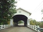
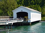
Fall Creek Lake (also known as Fall Creek Reservoir) is a reservoir in Lane County, in the U.S. state of Oregon. It is about 22 miles (35 km) southeast of Eugene on Fall Creek, immediately upstream from Unity Bridge, a covered bridge. The communities of Unity, at the bridge site, and Lowell, south of Unity, are near the lake. The unincorporated community of Jasper is further downstream, below the confluence of Fall Creek with the Middle Fork Willamette River.Fall Creek Dam, 205 feet (62 m) high, impounds up to 125,000 acre-feet (154,000,000 m3) of water in the reservoir. The embankment dam is of the rockfill type with a gated concrete spillway and outlet controls for regulating lake levels. The lake includes two arms, one along the Fall Creek main stem and one along Winberry Creek, a tributary entering from the south.
Excerpt from the Wikipedia article Fall Creek Lake (License: CC BY-SA 3.0, Authors, Images).Fall Creek Lake
Wineberry Creek Road,
Geographical coordinates (GPS) Address Nearby Places Show on map
 Continue reading on Wikipedia
 Geographical coordinates (GPS)
| Latitude | Longitude |
|---|---|
| N 43.9425 ° | E -122.75694444444 ° |
Address
Wineberry Creek Road
Wineberry Creek Road
97452
Oregon, United States
Open on Google Maps