place

Unity Bridge (Lowell, Oregon)

1936 establishments in OregonBridges completed in 1936Covered bridges in Lane County, OregonCovered bridges on the National Register of Historic Places in OregonHowe truss bridges in the United States
National Register of Historic Places in Lane County, OregonOregon Registered Historic Place stubsOregon building and structure stubsOregon transportation stubsRoad bridges on the National Register of Historic Places in OregonUse mdy dates from August 2023Western United States bridge (structure) stubsWooden bridges in Oregon
Unity Bridge, Big Fall Creek

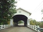
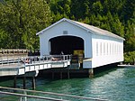
Unity Bridge (World Guide Number 37-20-170) is an historic 90-foot (27 m) long covered bridge over Fall Creek at Unity near Lowell in Lane County, Oregon, United States. Also known as Unity Covered Bridge and Unity Creek Bridge, it was built in 1936 at a cost $4,400 by Lane County using the Howe truss system. Its east side features a full-length window with its own roof so that drivers can see oncoming cars.The Unity Bridge was preceded by a covered bridge built in 1890. Limited to foot-traffic only after 1936, it was removed in 1953. The Unity Bridge, which replaced the original bridge, is 0.75 miles (1.2 km) further upstream. It is about 1 mile (1.6 km) downstream of the dam impounding Fall Creek Lake.County officials temporarily closed the bridge for repairs in 1986. Work included a new floor, exterior painting, repair of piers and guardrails, and vandalism cleanup.The bridge carries Lowell–Unity Road over the creek. Unity Bridge was added to the National Register of Historic Places in 1979.

Excerpt from the Wikipedia article Unity Bridge (Lowell, Oregon) (License: CC BY-SA 3.0, Authors, Images).

Unity Bridge (Lowell, Oregon)
Big Fall Creek Road,

Geographical coordinates (GPS) Address Nearby Places
placeShow on map

Wikipedia: Unity Bridge (Lowell, Oregon)Continue reading on Wikipedia

Geographical coordinates (GPS)

Latitude Longitude
N 43.945277777778 ° E -122.77388888889 °
placeShow on map

Address

Big Fall Creek Road

Big Fall Creek Road
97452
Oregon, United States
mapOpen on Google Maps

Unity Bridge, Big Fall Creek
Share experience

Nearby Places

Elijah Bristow State Park

Elijah Bristow State Park is a state park in the U.S. state of Oregon, administered by the Oregon Parks and Recreation Department. It has more than 10 miles (16 km) of well-maintained trails along ponds, wetlands, meadows, and the Middle Fork Willamette River, and through forests of broadleaf and evergreen trees. The trails are open to horses, hikers, and mountain bikers, and there is a separate equestrian staging area popular with riding clubs.The 847-acre (343 ha) park was named for Elijah Bristow, one of the first pioneer settlers in Lane County. Located directly downstream of Dexter Reservoir, the site was originally called Dexter State Park. It was renamed in 1979 to honor Bristow, who founded the nearby community of Pleasant Hill in the mid-19th century.The park's trail system includes part of a trail linking Alton Baker Park in Eugene to the Pacific Crest Trail near Oakridge. Named trails in the park include Equestrian, River, Lost Creek, Pond Loop, and Fishermen's, which interconnect "like a tangle of intersecting puzzle pieces".Wildlife in the park includes salmon and steelhead, osprey, great blue herons, bald eagles and beaver. Among the thousands of species in the park are the threatened Western pond turtle and the Oregon chub.Activities, in addition to hiking, horse riding, biking, and fishing, include wildlife watching, picnicking, and boating. A wildlife viewing platform overlooks the pond complex in the park.